Puebla de Sancho Pérez geodata
Puebla de Sancho Pérez (Extremadura) is a seat of a third-order administrative division; located in Spain in Europe/Madrid (GMT+2) time zone. With population of 2,861 people, there are 1769 cities with bigger population in this country. Compared to other cities in Spain, 86.2% of cities are located further ↑North; 90.3% of cities are located further →East and 60.5% of cities have higher elevation than Puebla de Sancho Pérez. Note1
Administrative division(s):
- Level 1: Extremadura
- Level 2: Provincia de Badajoz
- Level 3: Puebla de Sancho Pérez
Current local time in Puebla de Sancho Pérez:
09:17 PM, ThursdayDifference from your time zone: hours


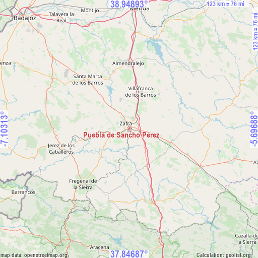
Puebla de Sancho Pérez GPS coordinates[2]
38° 24' 0" North, 6° 24' 0" West
| Map corner | latitude | longitude |
|---|---|---|
| Upper-left | 38.94893°, | -7.10313° |
| Center: | 38.4°, | -6.4° |
| Lower-right: | 37.84687°, | -5.69688° |
| Map W x H: | 122.5×122.5 km | = 76.1×76.1mi |
| max Lat: | 43.74134° ⇑86.2% North |
| Puebla de Sancho Pérez: | 38.4° |
| min Lat: | ⇓13.8% South 27.64134° |
| min Long | Puebla de Sanch | max Long |
| -18.00367° | -6.4° | 4.2899° |
| W 9.7%⇐ | ⇒90.3% E |
Elevation
Elevation of Puebla de Sancho Pérez is 520 m = 1706 ft, and this is 78 m = 256 ft below average elevation for this country.
| Max E: |
1682 m = 5518 ft | 60.5% |
| Avg. | 598 m = 1962 ft | |
| Puebla de Sancho Pérez | 520 m = 1706 ft | |
Min E: |
0 m = 0 ft | 39.5% |
See also: Spain elevation on elevation.city.
Geographical zone
Puebla de Sancho Pérez is located in North temperate zone (between Tropic of Cancer and the Arctic Circle). Distance of this Northern Tropic circle is 1663.8 km =1033.8 mi to South.| Distance of | km | miles | from Puebla de Sancho Pérez |
|---|---|---|---|
| North Pole | 5737.4 | 3565.1 | to North |
| Arctic Circle | 3131.5 | 1945.8 | to North |
| Tropic Cancer | 1663.8 | 1033.8 | to South |
| Equator | 4269.7 | 2653.1 | to South |


Nearby cities:
15 places around Puebla de Sancho Pérez: (largest is in red/bold)
• Alconera
5.8 km =3.6 mi,  270°
270°
• Atalaya
9.4 km =5.8 mi,  218°
218°
• Bienvenida
20.7 km =12.9 mi,  122°
122°
• Burguillos del Cerro
16.7 km =10.4 mi,  262°
262°
• Calzadilla de Los Barros
13.3 km =8.3 mi,  146°
146°
• Feria
18.9 km =11.7 mi,  310°
310°
• Fuente de Cantos
18.8 km =11.7 mi, 152°
• Fuente del Maestre
14.7 km =9.1 mi,  343°
343°
• Hinojosa del Valle
21 km =13 mi,  63°
63°
• Los Santos de Maimona
5.7 km =3.5 mi,  14°
14°
• Medina de las Torres
7.4 km =4.6 mi,  180°
180°
• Valencia del Ventoso
15.9 km =9.9 mi,  201°
201°
• Valverde de Burguillos
14.4 km =8.9 mi,  235°
235°
• Villafranca de los Barros
18.7 km =11.6 mi,  16°
16°
• Zafra
3.2 km =2 mi,  331°
331°
Sources, notices
• [Note1] Compared only with cities in Spain existing in our database
• [Src1] Map data: © OpenStreetMap contributors (CC-BY-SA)
• [Src2] Other city data from geonames.org with taken over terms of usage.
• [Src3] Geographical zone / Annual Mean Temperature by Robert A. Rohde @ Wikipedia
