La Parra geodata
La Parra (Extremadura) is a populated place; located in Spain in Europe/Madrid (GMT+2) time zone. With population of 1,432 people, there are 2524 cities with bigger population in this country. Compared to other cities in Spain, 85.5% of cities are located further ↑North; 92% of cities are located further →East and 60.6% of cities have higher elevation than La Parra. Note1


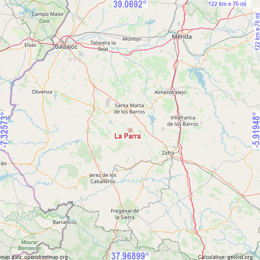
La Parra GPS coordinates[2]
38° 31' 16.32" North, 6° 37' 21.36" West
| Map corner | latitude | longitude |
|---|---|---|
| Upper-left | 39.0692°, | -7.32573° |
| Center: | 38.5212°, | -6.6226° |
| Lower-right: | 37.96899°, | -5.91948° |
| Map W x H: | 122.3×122.3 km | = 76×76mi |
| max Lat: | 43.74134° ⇑85.5% North |
| La Parra: | 38.5212° |
| min Lat: | ⇓14.5% South 27.64134° |
| min Long | La Parra | max Long |
| -18.00367° | -6.6226° | 4.2899° |
| W 8%⇐ | ⇒92% E |
Elevation
Elevation of La Parra is 519 m = 1703 ft, and this is 79 m = 259 ft below average elevation for this country.
| Max E: |
1682 m = 5518 ft | 60.6% |
| Avg. | 598 m = 1962 ft | |
| La Parra | 519 m = 1703 ft | |
Min E: |
0 m = 0 ft | 39.4% |
See also: Spain elevation on elevation.city.
Geographical zone
La Parra is located in North temperate zone (between Tropic of Cancer and the Arctic Circle). Distance of this Northern Tropic circle is 1677.2 km =1042.2 mi to South.| Distance of | km | miles | from La Parra |
|---|---|---|---|
| North Pole | 5723.9 | 3556.7 | to North |
| Arctic Circle | 3118 | 1937.4 | to North |
| Tropic Cancer | 1677.2 | 1042.2 | to South |
| Equator | 4283.2 | 2661.5 | to South |


Nearby cities:
15 places around La Parra: (largest is in red/bold)
• Aceuchal
18.3 km =11.4 mi,  40°
40°
• Alconera
19.1 km =11.9 mi,  134°
134°
• Almendral
20.1 km =12.5 mi,  300°
300°
• Barcarrota
19.7 km =12.2 mi,  267°
267°
• Burguillos del Cerro
15.9 km =9.9 mi,  169°
169°
• Feria
5.2 km =3.2 mi,  101°
101°
• Fuente del Maestre
15.2 km =9.4 mi,  87°
87°
• La Morera
3.8 km =2.4 mi,  315°
315°
• Nogales
13.2 km =8.2 mi, 303°
• Salvaleón
14.3 km =8.9 mi, 265°
• Salvatierra de los Barros
6.3 km =3.9 mi,  237°
237°
• Santa Marta
10.4 km =6.5 mi,  357°
357°
• Torre de Miguel Sesmero
18.6 km =11.6 mi,  305°
305°
• Villalba de los Barros
14.2 km =8.8 mi, 44°
• Zafra
20.8 km =12.9 mi,  120°
120°
Sources, notices
• [Note1] Compared only with cities in Spain existing in our database
• [Src1] Map data: © OpenStreetMap contributors (CC-BY-SA)
• [Src2] Other city data from geonames.org with taken over terms of usage.
• [Src3] Geographical zone / Annual Mean Temperature by Robert A. Rohde @ Wikipedia
