Feria geodata
Feria (Extremadura) is a seat of a third-order administrative division; located in Spain in Europe/Madrid (GMT+2) time zone. With population of 1,383 people, there are 2562 cities with bigger population in this country. Compared to other cities in Spain, 85.6% of cities are located further ↑North; 91.7% of cities are located further →East and 58.1% of cities have higher elevation than Feria. Note1


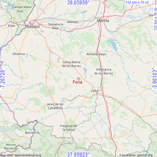
Feria GPS coordinates[2]
38° 30' 41.436" North, 6° 33' 50.976" West
| Map corner | latitude | longitude |
|---|---|---|
| Upper-left | 39.05959°, | -7.26728° |
| Center: | 38.51151°, | -6.56416° |
| Lower-right: | 37.95923°, | -5.86103° |
| Map W x H: | 122.3×122.3 km | = 76×76mi |
| max Lat: | 43.74134° ⇑85.6% North |
| Feria: | 38.51151° |
| min Lat: | ⇓14.4% South 27.64134° |
| min Long | Feria | max Long |
| -18.00367° | -6.56416° | 4.2899° |
| W 8.3%⇐ | ⇒91.7% E |
Elevation
Elevation of Feria is 551 m = 1808 ft, and this is 47 m = 154 ft below average elevation for this country.
| Max E: |
1682 m = 5518 ft | 58.1% |
| Avg. | 598 m = 1962 ft | |
| Feria | 551 m = 1808 ft | |
Min E: |
0 m = 0 ft | 41.9% |
See also: Spain elevation on elevation.city.
Geographical zone
Feria is located in North temperate zone (between Tropic of Cancer and the Arctic Circle). Distance of this Northern Tropic circle is 1676.2 km =1041.5 mi to South.| Distance of | km | miles | from Feria |
|---|---|---|---|
| North Pole | 5725 | 3557.3 | to North |
| Arctic Circle | 3119.1 | 1938.1 | to North |
| Tropic Cancer | 1676.2 | 1041.5 | to South |
| Equator | 4282.1 | 2660.8 | to South |


Nearby cities:
15 places around Feria: (largest is in red/bold)
• Aceuchal
16.4 km =10.2 mi,  24°
24°
• Alconera
15 km =9.3 mi,  145°
145°
• Burguillos del Cerro
14.8 km =9.2 mi,  188°
188°
• Fuente del Maestre
10.3 km =6.4 mi,  80°
80°
• La Morera
8.6 km =5.3 mi,  296°
296°
• La Parra
5.2 km =3.2 mi,  281°
281°
• Los Santos de Maimona
17.2 km =10.7 mi,  113°
113°
• Nogales
18.1 km =11.2 mi, 297°
• Puebla de Sancho Pérez
18.9 km =11.7 mi,  130°
130°
• Salvaleón
19.3 km =12 mi,  269°
269°
• Salvatierra de los Barros
10.7 km =6.6 mi,  257°
257°
• Santa Marta
12.7 km =7.9 mi,  334°
334°
• Villafranca de los Barros
20.4 km =12.7 mi,  74°
74°
• Villalba de los Barros
12.3 km =7.6 mi, 22°
• Zafra
16 km =9.9 mi, 126°
Sources, notices
• [Note1] Compared only with cities in Spain existing in our database
• [Src1] Map data: © OpenStreetMap contributors (CC-BY-SA)
• [Src2] Other city data from geonames.org with taken over terms of usage.
• [Src3] Geographical zone / Annual Mean Temperature by Robert A. Rohde @ Wikipedia
