Villanueva de los Castillejos geodata
Villanueva de los Castillejos (Andalusia) is a seat of a third-order administrative division; located in Spain in Europe/Madrid (GMT+2) time zone. With population of 827 people, there are 3168 cities with bigger population in this country. Compared to other cities in Spain, 91.3% of cities are located further ↑North; 95% of cities are located further →East and 80.6% of cities have higher elevation than Villanueva de los Castillejos. Note1
Administrative division(s):
- Level 1: Andalusia
- Level 2: Provincia de Huelva
- Level 3: Villanueva de los Castillejos
Current local time in Villanueva de los Castillejos:
10:42 PM, ThursdayDifference from your time zone: hours


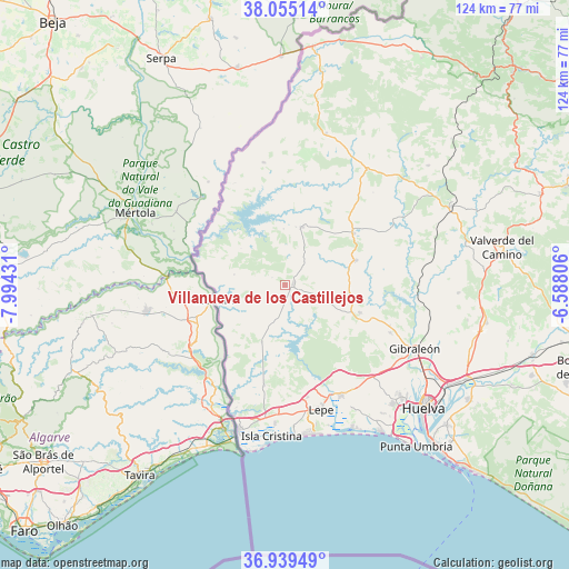
Villanueva de los Castillejos GPS coordinates[2]
37° 29' 57.84" North, 7° 17' 28.248" West
| Map corner | latitude | longitude |
|---|---|---|
| Upper-left | 38.05514°, | -7.99431° |
| Center: | 37.4994°, | -7.29118° |
| Lower-right: | 36.93949°, | -6.58806° |
| Map W x H: | 124×124 km | = 77.1×77.1mi |
| max Lat: | 43.74134° ⇑91.3% North |
| Villanueva de los Castillejos: | 37.4994° |
| min Lat: | ⇓8.7% South 27.64134° |
| min Long | Villanueva de l | max Long |
| -18.00367° | -7.29118° | 4.2899° |
| W 5%⇐ | ⇒95% E |
Elevation
Elevation of Villanueva de los Castillejos is 210 m = 689 ft, and this is 388 m = 1273 ft below average elevation for this country.
| Max E: |
1682 m = 5518 ft | 80.6% |
| Avg. | 598 m = 1962 ft | |
| Villanueva de los Castillejos | 210 m = 689 ft | |
Min E: |
0 m = 0 ft | 19.4% |
See also: Spain elevation on elevation.city.
Geographical zone
Villanueva de los Castillejos is located in North temperate zone (between Tropic of Cancer and the Arctic Circle). Distance of this Northern Tropic circle is 1563.6 km =971.6 mi to South.| Distance of | km | miles | from Villanueva de los Castillejos |
|---|---|---|---|
| North Pole | 5837.5 | 3627.3 | to North |
| Arctic Circle | 3231.6 | 2008 | to North |
| Tropic Cancer | 1563.6 | 971.6 | to South |
| Equator | 4169.5 | 2590.8 | to South |


Nearby cities:
15 places around Villanueva de los Castillejos: (largest is in red/bold)
• Alosno
16.5 km =10.3 mi,  70°
70°
• Cabezas Rubias
31 km =19.3 mi,  35°
35°
• Cartaya
27.3 km =17 mi,  152°
152°
• El Granado
11.2 km =7 mi,  281°
281°
• Gibraleón
31.6 km =19.6 mi,  115°
115°
• Islantilla
33 km =20.5 mi,  171°
171°
• La Antilla
33.3 km =20.7 mi, 167°
• Lepe
28.3 km =17.6 mi,  164°
164°
• Paymogo
27.2 km =16.9 mi,  349°
349°
• Puebla de Guzmán
13.3 km =8.3 mi,  16°
16°
• San Bartolomé de la Torre
17.4 km =10.8 mi,  110°
110°
• San Silvestre de Guzmán
13.4 km =8.3 mi,  202°
202°
• Sanlúcar de Guadiana
15.7 km =9.8 mi,  259°
259°
• Villablanca
22.4 km =13.9 mi,  192°
192°
• Villanueva de las Cruces
27.6 km =17.1 mi,  58°
58°
Sources, notices
• [Note1] Compared only with cities in Spain existing in our database
• [Src1] Map data: © OpenStreetMap contributors (CC-BY-SA)
• [Src2] Other city data from geonames.org with taken over terms of usage.
• [Src3] Geographical zone / Annual Mean Temperature by Robert A. Rohde @ Wikipedia
