La Antilla geodata
La Antilla (Andalusia) is a populated place; located in Spain in Europe/Madrid (GMT+2) time zone. With population of 3,500 people, there are 1587 cities with bigger population in this country. Compared to other cities in Spain, 93.9% of cities are located further ↑North; 94.8% of cities are located further →East and 98.7% of cities have higher elevation than La Antilla. Note1


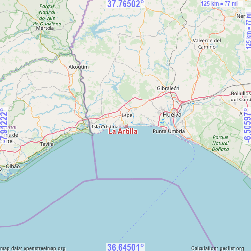
La Antilla GPS coordinates[2]
37° 12' 25.524" North, 7° 12' 32.724" West
| Map corner | latitude | longitude |
|---|---|---|
| Upper-left | 37.76502°, | -7.91222° |
| Center: | 37.20709°, | -7.20909° |
| Lower-right: | 36.64501°, | -6.50597° |
| Map W x H: | 124.5×124.5 km | = 77.4×77.4mi |
| max Lat: | 43.74134° ⇑93.9% North |
| La Antilla: | 37.20709° |
| min Lat: | ⇓6.1% South 27.64134° |
| min Long | La Antilla | max Long |
| -18.00367° | -7.20909° | 4.2899° |
| W 5.2%⇐ | ⇒94.8% E |
Elevation
Elevation of La Antilla is 9 m = 30 ft, and this is 589 m = 1932 ft below average elevation for this country.
| Max E: |
1682 m = 5518 ft | 98.7% |
| Avg. | 598 m = 1962 ft | |
| La Antilla | 9 m = 30 ft | |
Min E: |
0 m = 0 ft | 1.3% |
See also: Spain elevation on elevation.city.
Geographical zone
La Antilla is located in North temperate zone (between Tropic of Cancer and the Arctic Circle). Distance of this Northern Tropic circle is 1531.1 km =951.4 mi to South.| Distance of | km | miles | from La Antilla |
|---|---|---|---|
| North Pole | 5870 | 3647.4 | to North |
| Arctic Circle | 3264.1 | 2028.2 | to North |
| Tropic Cancer | 1531.1 | 951.4 | to South |
| Equator | 4137 | 2570.6 | to South |


Nearby cities:
15 places around La Antilla: (largest is in red/bold)
• Aljaraque
17.9 km =11.1 mi,  67°
67°
• Ayamonte
17.6 km =10.9 mi,  272°
272°
• Cartaya
9.7 km =6 mi,  32°
32°
• El Rompido
7.8 km =4.8 mi,  81°
81°
• Gibraleón
28.4 km =17.6 mi,  48°
48°
• Huelva
24.7 km =15.3 mi, 74°
• Isla Cristina
9.6 km =6 mi, 265°
• Islantilla
2.5 km =1.6 mi, 266°
• Lepe
5.3 km =3.3 mi,  4°
4°
• Palos de la Frontera
28 km =17.4 mi, 83°
• Punta Umbría
21.7 km =13.5 mi,  97°
97°
• San Bartolomé de la Torre
28 km =17.4 mi,  19°
19°
• San Silvestre de Guzmán
23.6 km =14.7 mi,  328°
328°
• Villablanca
16 km =9.9 mi,  311°
311°
• Villanueva de los Castillejos
33.3 km =20.7 mi,  347°
347°
Sources, notices
• [Note1] Compared only with cities in Spain existing in our database
• [Src1] Map data: © OpenStreetMap contributors (CC-BY-SA)
• [Src2] Other city data from geonames.org with taken over terms of usage.
• [Src3] Geographical zone / Annual Mean Temperature by Robert A. Rohde @ Wikipedia
