Paymogo geodata
Paymogo (Andalusia) is a seat of a third-order administrative division; located in Spain in Europe/Madrid (GMT+2) time zone. With population of 1,310 people, there are 2631 cities with bigger population in this country. Compared to other cities in Spain, 89.9% of cities are located further ↑North; 95.1% of cities are located further →East and 82.5% of cities have higher elevation than Paymogo. Note1


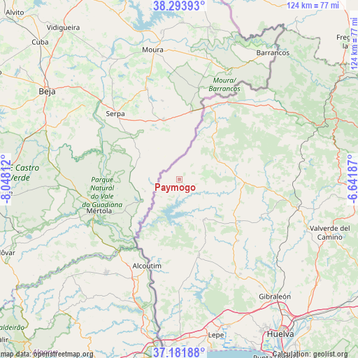
Paymogo GPS coordinates[2]
37° 44' 23.964" North, 7° 20' 41.964" West
| Map corner | latitude | longitude |
|---|---|---|
| Upper-left | 38.29393°, | -8.04812° |
| Center: | 37.73999°, | -7.34499° |
| Lower-right: | 37.18188°, | -6.64187° |
| Map W x H: | 123.6×123.6 km | = 76.8×76.8mi |
| max Lat: | 43.74134° ⇑89.9% North |
| Paymogo: | 37.73999° |
| min Lat: | ⇓10.1% South 27.64134° |
| min Long | Paymogo | max Long |
| -18.00367° | -7.34499° | 4.2899° |
| W 4.9%⇐ | ⇒95.1% E |
Elevation
Elevation of Paymogo is 177 m = 581 ft, and this is 421 m = 1381 ft below average elevation for this country.
| Max E: |
1682 m = 5518 ft | 82.5% |
| Avg. | 598 m = 1962 ft | |
| Paymogo | 177 m = 581 ft | |
Min E: |
0 m = 0 ft | 17.5% |
See also: Spain elevation on elevation.city.
Geographical zone
Paymogo is located in North temperate zone (between Tropic of Cancer and the Arctic Circle). Distance of this Northern Tropic circle is 1590.4 km =988.2 mi to South.| Distance of | km | miles | from Paymogo |
|---|---|---|---|
| North Pole | 5810.8 | 3610.7 | to North |
| Arctic Circle | 3204.9 | 1991.4 | to North |
| Tropic Cancer | 1590.4 | 988.2 | to South |
| Equator | 4196.3 | 2607.5 | to South |


Nearby cities:
15 places around Paymogo: (largest is in red/bold)
• Alosno
29.4 km =18.3 mi,  136°
136°
• Aroche
40.8 km =25.4 mi,  56°
56°
• Cabezas Rubias
22.7 km =14.1 mi,  93°
93°
• Calañas
41.9 km =26 mi,  102°
102°
• El Cerro de Andévalo
35.9 km =22.3 mi, 90°
• El Granado
25.3 km =15.7 mi,  194°
194°
• Puebla de Guzmán
16.3 km =10.1 mi,  148°
148°
• Rosal de la Frontera
27.6 km =17.1 mi,  23°
23°
• San Bartolomé de la Torre
39 km =24.2 mi, 147°
• San Silvestre de Guzmán
39.2 km =24.4 mi,  180°
180°
• Sanlúcar de Guadiana
31.6 km =19.6 mi,  199°
199°
• Santa Bárbara de Casa
15.2 km =9.4 mi,  65°
65°
• Villablanca
48.7 km =30.3 mi, 179°
• Villanueva de las Cruces
30.9 km =19.2 mi,  113°
113°
• Villanueva de los Castillejos
27.2 km =16.9 mi,  169°
169°
Sources, notices
• [Note1] Compared only with cities in Spain existing in our database
• [Src1] Map data: © OpenStreetMap contributors (CC-BY-SA)
• [Src2] Other city data from geonames.org with taken over terms of usage.
• [Src3] Geographical zone / Annual Mean Temperature by Robert A. Rohde @ Wikipedia
