Villablanca geodata
Villablanca (Andalusia) is a seat of a third-order administrative division; located in Spain in Europe/Madrid (GMT+2) time zone. With population of 2,286 people, there are 2007 cities with bigger population in this country. Compared to other cities in Spain, 92.9% of cities are located further ↑North; 95.1% of cities are located further →East and 88.5% of cities have higher elevation than Villablanca. Note1


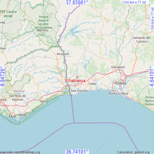
Villablanca GPS coordinates[2]
37° 18' 8.604" North, 7° 20' 38.868" West
| Map corner | latitude | longitude |
|---|---|---|
| Upper-left | 37.85961°, | -8.04726° |
| Center: | 37.30239°, | -7.34413° |
| Lower-right: | 36.74101°, | -6.64101° |
| Map W x H: | 124.4×124.4 km | = 77.3×77.3mi |
| max Lat: | 43.74134° ⇑92.9% North |
| Villablanca: | 37.30239° |
| min Lat: | ⇓7.1% South 27.64134° |
| min Long | Villablanca | max Long |
| -18.00367° | -7.34413° | 4.2899° |
| W 4.9%⇐ | ⇒95.1% E |
Elevation
Elevation of Villablanca is 87 m = 285 ft, and this is 511 m = 1677 ft below average elevation for this country.
| Max E: |
1682 m = 5518 ft | 88.5% |
| Avg. | 598 m = 1962 ft | |
| Villablanca | 87 m = 285 ft | |
Min E: |
0 m = 0 ft | 11.5% |
See also: Spain elevation on elevation.city.
Geographical zone
Villablanca is located in North temperate zone (between Tropic of Cancer and the Arctic Circle). Distance of this Northern Tropic circle is 1541.7 km =958 mi to South.| Distance of | km | miles | from Villablanca |
|---|---|---|---|
| North Pole | 5859.4 | 3640.9 | to North |
| Arctic Circle | 3253.5 | 2021.6 | to North |
| Tropic Cancer | 1541.7 | 958 | to South |
| Equator | 4147.6 | 2577.2 | to South |


Nearby cities:
15 places around Villablanca: (largest is in red/bold)
• Aljaraque
28.6 km =17.8 mi,  97°
97°
• Alosno
34.1 km =21.2 mi,  36°
36°
• Ayamonte
11.4 km =7.1 mi,  209°
209°
• Cartaya
17.3 km =10.7 mi, 97°
• El Granado
25 km =15.5 mi,  345°
345°
• El Rompido
21.8 km =13.5 mi,  115°
115°
• Gibraleón
34.2 km =21.3 mi,  76°
76°
• Isla Cristina
11.6 km =7.2 mi,  167°
167°
• Islantilla
14.3 km =8.9 mi,  138°
138°
• La Antilla
16 km =9.9 mi,  131°
131°
• Lepe
13.5 km =8.4 mi,  113°
113°
• San Bartolomé de la Torre
26.4 km =16.4 mi,  52°
52°
• San Silvestre de Guzmán
9.5 km =5.9 mi,  357°
357°
• Sanlúcar de Guadiana
21.8 km =13.5 mi,  330°
330°
• Villanueva de los Castillejos
22.4 km =13.9 mi,  12°
12°
Sources, notices
• [Note1] Compared only with cities in Spain existing in our database
• [Src1] Map data: © OpenStreetMap contributors (CC-BY-SA)
• [Src2] Other city data from geonames.org with taken over terms of usage.
• [Src3] Geographical zone / Annual Mean Temperature by Robert A. Rohde @ Wikipedia
