Villamayor de Santiago geodata
Villamayor de Santiago (Castille-La Mancha) is a seat of a third-order administrative division; located in Spain in Europe/Madrid (GMT+2) time zone. With population of 2,766 people, there are 1792 cities with bigger population in this country. Compared to other cities in Spain, 73.8% of cities are located further ↑North; 55.7% of cities are located further ←West and 65.5% of cities have lower elevation than Villamayor de Santiago. Note1
Administrative division(s):
- Level 1: Castille-La Mancha
- Level 2: Provincia de Cuenca
- Level 3: Villamayor de Santiago
Current local time in Villamayor de Santiago:
09:16 PM, ThursdayDifference from your time zone: hours


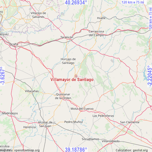
Villamayor de Santiago GPS coordinates[2]
39° 43' 50.592" North, 2° 55' 24.852" West
| Map corner | latitude | longitude |
|---|---|---|
| Upper-left | 40.26934°, | -3.6267° |
| Center: | 39.73072°, | -2.92357° |
| Lower-right: | 39.18786°, | -2.22045° |
| Map W x H: | 120.2×120.2 km | = 74.7×74.7mi |
| max Lat: | 43.74134° ⇑73.8% North |
| Villamayor de Santiago: | 39.73072° |
| min Lat: | ⇓26.2% South 27.64134° |
| min Long | Villamayor de S | max Long |
| -18.00367° | -2.92357° | 4.2899° |
| W 55.7%⇐ | ⇒44.3% E |
Elevation
Elevation of Villamayor de Santiago is 781 m = 2562 ft, and this is 183 m = 600 ft above average elevation for this country.
| Max E: |
1682 m = 5518 ft | 34.5% |
| Villamayor de Santiago | 781 m 2562 ft | |
| Avg. | 598 m = 1962 ft | |
Min E: |
0 m = 0 ft | 65.5% |
See also: Spain elevation on elevation.city.
Geographical zone
Villamayor de Santiago is located in North temperate zone (between Tropic of Cancer and the Arctic Circle). Distance of this Northern Tropic circle is 1811.7 km =1125.7 mi to South.| Distance of | km | miles | from Villamayor de Santiago |
|---|---|---|---|
| North Pole | 5589.4 | 3473.1 | to North |
| Arctic Circle | 2983.5 | 1853.9 | to North |
| Tropic Cancer | 1811.7 | 1125.7 | to South |
| Equator | 4417.6 | 2745 | to South |


Nearby cities:
15 places around Villamayor de Santiago: (largest is in red/bold)
• Almonacid del Marquesado
16.8 km =10.4 mi,  52°
52°
• Cabezamesada
18 km =11.2 mi,  301°
301°
• Corral de Almaguer
20.9 km =13 mi,  278°
278°
• Hontanaya
7.7 km =4.8 mi,  102°
102°
• Horcajo de Santiago
13.9 km =8.6 mi,  333°
333°
• La Puebla de Almoradiel
22.2 km =13.8 mi,  228°
228°
• Los Hinojosos
16.4 km =10.2 mi,  149°
149°
• Osa de la Vega
16.1 km =10 mi,  119°
119°
• Pozorrubio
9.8 km =6.1 mi,  346°
346°
• Puebla de Almenara
11.1 km =6.9 mi,  57°
57°
• Quintanar de la Orden
18.3 km =11.4 mi,  213°
213°
• Torrubia del Campo
18.8 km =11.7 mi, 350°
• Tresjuncos
14.8 km =9.2 mi, 102°
• Villanueva de Alcardete
10.1 km =6.3 mi, 230°
• Villarejo de Fuentes
20.4 km =12.7 mi,  71°
71°
Sources, notices
• [Note1] Compared only with cities in Spain existing in our database
• [Src1] Map data: © OpenStreetMap contributors (CC-BY-SA)
• [Src2] Other city data from geonames.org with taken over terms of usage.
• [Src3] Geographical zone / Annual Mean Temperature by Robert A. Rohde @ Wikipedia
