Aljaraque geodata
Aljaraque (Andalusia) is a seat of a third-order administrative division; located in Spain in Europe/Madrid (GMT+2) time zone. With population of 17,960 people, there are 522 cities with bigger population in this country. Compared to other cities in Spain, 93.2% of cities are located further ↑North; 94.3% of cities are located further →East and 94.1% of cities have higher elevation than Aljaraque. Note1


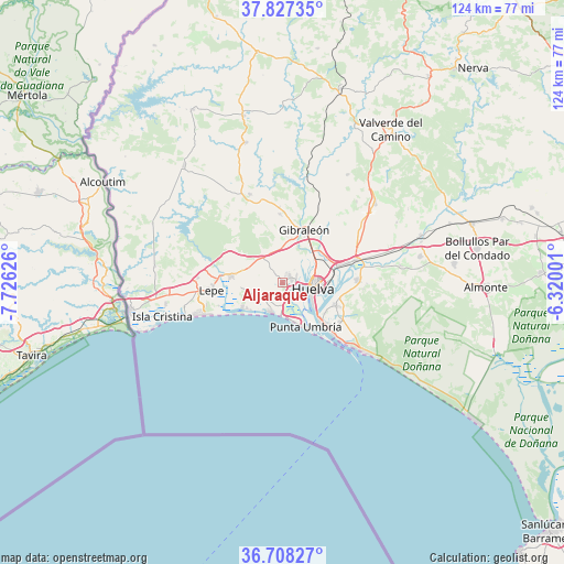
Aljaraque GPS coordinates[2]
37° 16' 11.604" North, 7° 1' 23.268" West
| Map corner | latitude | longitude |
|---|---|---|
| Upper-left | 37.82735°, | -7.72626° |
| Center: | 37.26989°, | -7.02313° |
| Lower-right: | 36.70827°, | -6.32001° |
| Map W x H: | 124.4×124.4 km | = 77.3×77.3mi |
| max Lat: | 43.74134° ⇑93.2% North |
| Aljaraque: | 37.26989° |
| min Lat: | ⇓6.8% South 27.64134° |
| min Long | Aljaraque | max Long |
| -18.00367° | -7.02313° | 4.2899° |
| W 5.7%⇐ | ⇒94.3% E |
Elevation
Elevation of Aljaraque is 30 m = 98 ft, and this is 568 m = 1864 ft below average elevation for this country.
| Max E: |
1682 m = 5518 ft | 94.1% |
| Avg. | 598 m = 1962 ft | |
| Aljaraque | 30 m = 98 ft | |
Min E: |
0 m = 0 ft | 5.9% |
See also: Spain elevation on elevation.city.
Geographical zone
Aljaraque is located in North temperate zone (between Tropic of Cancer and the Arctic Circle). Distance of this Northern Tropic circle is 1538.1 km =955.7 mi to South.| Distance of | km | miles | from Aljaraque |
|---|---|---|---|
| North Pole | 5863 | 3643.1 | to North |
| Arctic Circle | 3257.2 | 2023.9 | to North |
| Tropic Cancer | 1538.1 | 955.7 | to South |
| Equator | 4144 | 2575 | to South |


Nearby cities:
15 places around Aljaraque: (largest is in red/bold)
• Cartaya
11.4 km =7.1 mi,  276°
276°
• El Rompido
10.5 km =6.5 mi,  236°
236°
• Gibraleón
12.8 km =8 mi,  22°
22°
• Huelva
7.4 km =4.6 mi,  93°
93°
• Islantilla
20.3 km =12.6 mi,  249°
249°
• La Antilla
17.9 km =11.1 mi, 247°
• Lepe
16.1 km =10 mi,  264°
264°
• Lucena del Puerto
26.3 km =16.3 mi,  81°
81°
• Mazagón
22.8 km =14.2 mi,  130°
130°
• Moguer
16.3 km =10.1 mi, 87°
• Palos de la Frontera
12 km =7.5 mi,  109°
109°
• Punta Umbría
11 km =6.8 mi,  152°
152°
• San Bartolomé de la Torre
20.8 km =12.9 mi,  339°
339°
• San Juan del Puerto
16.9 km =10.5 mi,  72°
72°
• Trigueros
21.6 km =13.4 mi,  53°
53°
Sources, notices
• [Note1] Compared only with cities in Spain existing in our database
• [Src1] Map data: © OpenStreetMap contributors (CC-BY-SA)
• [Src2] Other city data from geonames.org with taken over terms of usage.
• [Src3] Geographical zone / Annual Mean Temperature by Robert A. Rohde @ Wikipedia
