Ayamonte geodata
Ayamonte (Andalusia) is a seat of a third-order administrative division; located in Spain in Europe/Madrid (GMT+2) time zone. With population of 20,334 people, there are 472 cities with bigger population in this country. Compared to other cities in Spain, 93.9% of cities are located further ↑North; 95.3% of cities are located further →East and 97.9% of cities have higher elevation than Ayamonte. Note1


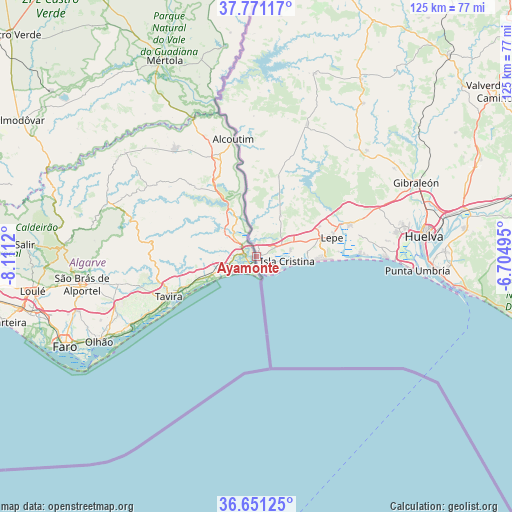
Ayamonte GPS coordinates[2]
37° 12' 47.844" North, 7° 24' 29.052" West
| Map corner | latitude | longitude |
|---|---|---|
| Upper-left | 37.77117°, | -8.1112° |
| Center: | 37.21329°, | -7.40807° |
| Lower-right: | 36.65125°, | -6.70495° |
| Map W x H: | 124.5×124.5 km | = 77.4×77.4mi |
| max Lat: | 43.74134° ⇑93.9% North |
| Ayamonte: | 37.21329° |
| min Lat: | ⇓6.1% South 27.64134° |
| min Long | Ayamonte | max Long |
| -18.00367° | -7.40807° | 4.2899° |
| W 4.7%⇐ | ⇒95.3% E |
Elevation
Elevation of Ayamonte is 12 m = 39 ft, and this is 586 m = 1923 ft below average elevation for this country.
| Max E: |
1682 m = 5518 ft | 97.9% |
| Avg. | 598 m = 1962 ft | |
| Ayamonte | 12 m = 39 ft | |
Min E: |
0 m = 0 ft | 2.1% |
See also: Spain elevation on elevation.city.
Geographical zone
Ayamonte is located in North temperate zone (between Tropic of Cancer and the Arctic Circle). Distance of this Northern Tropic circle is 1531.8 km =951.8 mi to South.| Distance of | km | miles | from Ayamonte |
|---|---|---|---|
| North Pole | 5869.3 | 3647 | to North |
| Arctic Circle | 3263.4 | 2027.8 | to North |
| Tropic Cancer | 1531.8 | 951.8 | to South |
| Equator | 4137.7 | 2571 | to South |


Nearby cities:
15 places around Ayamonte: (largest is in red/bold)
• Aljaraque
34.7 km =21.6 mi,  79°
79°
• Cartaya
24 km =14.9 mi,  71°
71°
• El Granado
34.1 km =21.2 mi,  358°
358°
• El Rompido
25.3 km =15.7 mi,  88°
88°
• Huelva
41.8 km =26 mi, 81°
• Isla Cristina
8.2 km =5.1 mi,  100°
100°
• Islantilla
15.1 km =9.4 mi, 93°
• La Antilla
17.6 km =10.9 mi, 92°
• Lepe
18.6 km =11.6 mi, 75°
• Punta Umbría
39.3 km =24.4 mi, 95°
• San Bartolomé de la Torre
37.1 km =23.1 mi,  46°
46°
• San Silvestre de Guzmán
20.1 km =12.5 mi,  15°
15°
• Sanlúcar de Guadiana
29.3 km =18.2 mi,  350°
350°
• Villablanca
11.4 km =7.1 mi,  29°
29°
• Villanueva de los Castillejos
33.4 km =20.8 mi, 17°
Sources, notices
• [Note1] Compared only with cities in Spain existing in our database
• [Src1] Map data: © OpenStreetMap contributors (CC-BY-SA)
• [Src2] Other city data from geonames.org with taken over terms of usage.
• [Src3] Geographical zone / Annual Mean Temperature by Robert A. Rohde @ Wikipedia
