Válor geodata
Válor (Andalusia) is a seat of a third-order administrative division; located in Spain in Europe/Madrid (GMT+2) time zone. With population of 743 people, there are 3319 cities with bigger population in this country. Compared to other cities in Spain, 95.3% of cities are located further ↑North; 53% of cities are located further ←West and 79.9% of cities have lower elevation than Válor. Note1


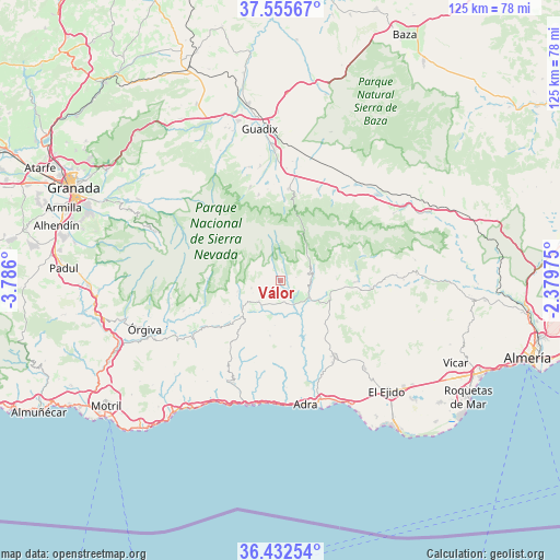
Válor GPS coordinates[2]
36° 59' 46.248" North, 3° 4' 58.332" West
| Map corner | latitude | longitude |
|---|---|---|
| Upper-left | 37.55567°, | -3.786° |
| Center: | 36.99618°, | -3.08287° |
| Lower-right: | 36.43254°, | -2.37975° |
| Map W x H: | 124.9×124.9 km | = 77.6×77.6mi |
| max Lat: | 43.74134° ⇑95.3% North |
| Válor: | 36.99618° |
| min Lat: | ⇓4.7% South 27.64134° |
| min Long | Válor | max Long |
| -18.00367° | -3.08287° | 4.2899° |
| W 53%⇐ | ⇒47% E |
Elevation
Elevation of Válor is 896 m = 2940 ft, and this is 298 m = 978 ft above average elevation for this country.
| Max E: |
1682 m = 5518 ft | 20.1% |
| Válor | 896 m 2940 ft | |
| Avg. | 598 m = 1962 ft | |
Min E: |
0 m = 0 ft | 79.9% |
See also: Spain elevation on elevation.city.
Geographical zone
Válor is located in North temperate zone (between Tropic of Cancer and the Arctic Circle). Distance of this Northern Tropic circle is 1507.7 km =936.8 mi to South.| Distance of | km | miles | from Válor |
|---|---|---|---|
| North Pole | 5893.5 | 3662 | to North |
| Arctic Circle | 3287.6 | 2042.8 | to North |
| Tropic Cancer | 1507.7 | 936.8 | to South |
| Equator | 4113.6 | 2556.1 | to South |


Nearby cities:
15 places around Válor: (largest is in red/bold)
• Alcolea
11 km =6.8 mi,  102°
102°
• Aldeire
18.3 km =11.4 mi,  3°
3°
• Bayárcal
8.6 km =5.3 mi,  63°
63°
• Bérchules
9.8 km =6.1 mi,  257°
257°
• Cádiar
10.3 km =6.4 mi,  237°
237°
• Cástaras
16.8 km =10.4 mi, 244°
• Darrícal
9.7 km =6 mi,  150°
150°
• Juviles
13.8 km =8.6 mi,  247°
247°
• Lanteira
19.8 km =12.3 mi,  345°
345°
• Laujar de Andarax
17.1 km =10.6 mi,  90°
90°
• Lobras
13.7 km =8.5 mi, 236°
• Murtas
12.6 km =7.8 mi,  190°
190°
• Paterna del Río
11.9 km =7.4 mi,  75°
75°
• Trevélez
16.2 km =10.1 mi,  271°
271°
• Ugíjar
4.6 km =2.9 mi, 147°
Sources, notices
• [Note1] Compared only with cities in Spain existing in our database
• [Src1] Map data: © OpenStreetMap contributors (CC-BY-SA)
• [Src2] Other city data from geonames.org with taken over terms of usage.
• [Src3] Geographical zone / Annual Mean Temperature by Robert A. Rohde @ Wikipedia
