Paterna del Río geodata
Paterna del Río (Andalusia) is a seat of a third-order administrative division; located in Spain in Europe/Madrid (GMT+2) time zone. With population of 417 people, there are 4084 cities with bigger population in this country. Compared to other cities in Spain, 95.1% of cities are located further ↑North; 55.2% of cities are located further ←West and 97.1% of cities have lower elevation than Paterna del Río. Note1


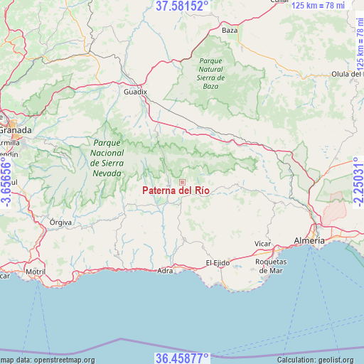
Paterna del Río GPS coordinates[2]
37° 1' 19.992" North, 2° 57' 12.348" West
| Map corner | latitude | longitude |
|---|---|---|
| Upper-left | 37.58152°, | -3.65656° |
| Center: | 37.02222°, | -2.95343° |
| Lower-right: | 36.45877°, | -2.25031° |
| Map W x H: | 124.8×124.8 km | = 77.5×77.5mi |
| max Lat: | 43.74134° ⇑95.1% North |
| Paterna del Río: | 37.02222° |
| min Lat: | ⇓4.9% South 27.64134° |
| min Long | Paterna del Rí | max Long |
| -18.00367° | -2.95343° | 4.2899° |
| W 55.2%⇐ | ⇒44.8% E |
Elevation
Elevation of Paterna del Río is 1209 m = 3967 ft, and this is 611 m = 2005 ft above average elevation for this country.
| Max E: |
1682 m = 5518 ft | 2.9% |
| Paterna del Río | 1209 m 3967 ft | |
| Avg. | 598 m = 1962 ft | |
Min E: |
0 m = 0 ft | 97.1% |
See also: Spain elevation on elevation.city.
Geographical zone
Paterna del Río is located in North temperate zone (between Tropic of Cancer and the Arctic Circle). Distance of this Northern Tropic circle is 1510.6 km =938.6 mi to South.| Distance of | km | miles | from Paterna del Río |
|---|---|---|---|
| North Pole | 5890.6 | 3660.2 | to North |
| Arctic Circle | 3284.7 | 2041 | to North |
| Tropic Cancer | 1510.6 | 938.6 | to South |
| Equator | 4116.5 | 2557.9 | to South |


Nearby cities:
15 places around Paterna del Río: (largest is in red/bold)
• Abrucena
18.5 km =11.5 mi,  48°
48°
• Alcolea
5.3 km =3.3 mi,  187°
187°
• Almócita
14.6 km =9.1 mi,  98°
98°
• Bayárcal
3.9 km =2.4 mi,  284°
284°
• Beires
14.4 km =8.9 mi,  94°
94°
• Darrícal
13.2 km =8.2 mi,  210°
210°
• Dólar
17.8 km =11.1 mi,  349°
349°
• Ferreira
18.2 km =11.3 mi,  336°
336°
• Fondón
9.6 km =6 mi,  119°
119°
• Huéneja
17.2 km =10.7 mi,  0°
0°
• Laujar de Andarax
6.4 km =4 mi, 118°
• Ohanes
18.6 km =11.6 mi,  84°
84°
• Padules
16.2 km =10.1 mi, 99°
• Ugíjar
11.3 km =7 mi,  232°
232°
• Válor
11.9 km =7.4 mi,  255°
255°
Sources, notices
• [Note1] Compared only with cities in Spain existing in our database
• [Src1] Map data: © OpenStreetMap contributors (CC-BY-SA)
• [Src2] Other city data from geonames.org with taken over terms of usage.
• [Src3] Geographical zone / Annual Mean Temperature by Robert A. Rohde @ Wikipedia
