Laujar de Andarax geodata
Laujar de Andarax (Andalusia) is a populated place; located in Spain in Europe/Madrid (GMT+2) time zone. With population of 1,811 people, there are 2279 cities with bigger population in this country. Compared to other cities in Spain, 95.3% of cities are located further ↑North; 56% of cities are located further ←West and 83.4% of cities have lower elevation than Laujar de Andarax. Note1


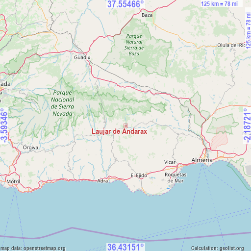
Laujar de Andarax GPS coordinates[2]
36° 59' 42.576" North, 2° 53' 25.188" West
| Map corner | latitude | longitude |
|---|---|---|
| Upper-left | 37.55466°, | -3.59346° |
| Center: | 36.99516°, | -2.89033° |
| Lower-right: | 36.43151°, | -2.18721° |
| Map W x H: | 124.9×124.9 km | = 77.6×77.6mi |
| max Lat: | 43.74134° ⇑95.3% North |
| Laujar de Andarax: | 36.99516° |
| min Lat: | ⇓4.7% South 27.64134° |
| min Long | Laujar de Andar | max Long |
| -18.00367° | -2.89033° | 4.2899° |
| W 56%⇐ | ⇒44% E |
Elevation
Elevation of Laujar de Andarax is 932 m = 3058 ft, and this is 334 m = 1096 ft above average elevation for this country.
| Max E: |
1682 m = 5518 ft | 16.6% |
| Laujar de Andarax | 932 m 3058 ft | |
| Avg. | 598 m = 1962 ft | |
Min E: |
0 m = 0 ft | 83.4% |
See also: Spain elevation on elevation.city.
Geographical zone
Laujar de Andarax is located in North temperate zone (between Tropic of Cancer and the Arctic Circle). Distance of this Northern Tropic circle is 1507.6 km =936.8 mi to South.| Distance of | km | miles | from Laujar de Andarax |
|---|---|---|---|
| North Pole | 5893.6 | 3662.1 | to North |
| Arctic Circle | 3287.7 | 2042.9 | to North |
| Tropic Cancer | 1507.6 | 936.8 | to South |
| Equator | 4113.5 | 2556 | to South |


Nearby cities:
15 places around Laujar de Andarax: (largest is in red/bold)
• Abrucena
17.3 km =10.7 mi,  28°
28°
• Alcolea
6.7 km =4.2 mi,  250°
250°
• Almócita
8.9 km =5.5 mi,  84°
84°
• Bayárcal
10.2 km =6.3 mi,  292°
292°
• Beires
9 km =5.6 mi, 77°
• Berja
17.3 km =10.7 mi,  197°
197°
• Canjáyar
13.5 km =8.4 mi, 83°
• Darrícal
14.9 km =9.3 mi,  235°
235°
• Fondón
3.2 km =2 mi,  121°
121°
• Ohanes
13.8 km =8.6 mi,  69°
69°
• Padules
10.4 km =6.5 mi,  88°
88°
• Paterna del Río
6.4 km =4 mi,  298°
298°
• Rágol
18.5 km =11.5 mi, 89°
• Ugíjar
15.1 km =9.4 mi,  255°
255°
• Válor
17.1 km =10.6 mi,  270°
270°
In other languages:
- In Italian: Láujar de Andarax
- In Russian: Лаухар-де-Андаракс
- In Chinese: 劳哈尔德亚恩达拉斯
Sources, notices
• [Note1] Compared only with cities in Spain existing in our database
• [Src1] Map data: © OpenStreetMap contributors (CC-BY-SA)
• [Src2] Other city data from geonames.org with taken over terms of usage.
• [Src3] Geographical zone / Annual Mean Temperature by Robert A. Rohde @ Wikipedia
