Darrícal geodata
Darrícal (Andalusia) is a populated place; located in Spain in Europe/Madrid (GMT+2) time zone. With population of 544 people, there are 3752 cities with bigger population in this country. Compared to other cities in Spain, 96% of cities are located further ↑North; 53.9% of cities are located further ←West and 69.7% of cities have higher elevation than Darrícal. Note1


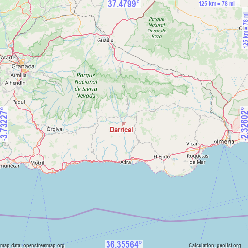
Darrícal GPS coordinates[2]
36° 55' 11.424" North, 3° 1' 44.904" West
| Map corner | latitude | longitude |
|---|---|---|
| Upper-left | 37.4799°, | -3.73227° |
| Center: | 36.91984°, | -3.02914° |
| Lower-right: | 36.35564°, | -2.32602° |
| Map W x H: | 125×125 km | = 77.7×77.7mi |
| max Lat: | 43.74134° ⇑96% North |
| Darrícal: | 36.91984° |
| min Lat: | ⇓4% South 27.64134° |
| min Long | Darrícal | max Long |
| -18.00367° | -3.02914° | 4.2899° |
| W 53.9%⇐ | ⇒46.1% E |
Elevation
Elevation of Darrícal is 386 m = 1266 ft, and this is 212 m = 696 ft below average elevation for this country.
| Max E: |
1682 m = 5518 ft | 69.7% |
| Avg. | 598 m = 1962 ft | |
| Darrícal | 386 m = 1266 ft | |
Min E: |
0 m = 0 ft | 30.3% |
See also: Spain elevation on elevation.city.
Geographical zone
Darrícal is located in North temperate zone (between Tropic of Cancer and the Arctic Circle). Distance of this Northern Tropic circle is 1499.2 km =931.6 mi to South.| Distance of | km | miles | from Darrícal |
|---|---|---|---|
| North Pole | 5902 | 3667.3 | to North |
| Arctic Circle | 3296.1 | 2048.1 | to North |
| Tropic Cancer | 1499.2 | 931.6 | to South |
| Equator | 4105.1 | 2550.8 | to South |


Nearby cities:
15 places around Darrícal: (largest is in red/bold)
• Adra
18.9 km =11.7 mi,  177°
177°
• Alcolea
8.6 km =5.3 mi,  44°
44°
• Bayárcal
12.7 km =7.9 mi,  13°
13°
• Berja
10.8 km =6.7 mi,  138°
138°
• Bérchules
15.7 km =9.8 mi,  293°
293°
• Cádiar
13.7 km =8.5 mi,  282°
282°
• Dalías
17.8 km =11.1 mi,  127°
127°
• Fondón
16.5 km =10.3 mi,  65°
65°
• Juviles
17.8 km =11.1 mi, 280°
• Laujar de Andarax
14.9 km =9.3 mi,  55°
55°
• Lobras
16.3 km =10.1 mi,  273°
273°
• Murtas
8.1 km =5 mi,  241°
241°
• Paterna del Río
13.2 km =8.2 mi,  30°
30°
• Ugíjar
5.1 km =3.2 mi,  333°
333°
• Válor
9.7 km =6 mi, 330°
Sources, notices
• [Note1] Compared only with cities in Spain existing in our database
• [Src1] Map data: © OpenStreetMap contributors (CC-BY-SA)
• [Src2] Other city data from geonames.org with taken over terms of usage.
• [Src3] Geographical zone / Annual Mean Temperature by Robert A. Rohde @ Wikipedia
