Valdepeñas geodata
Valdepeñas (Castille-La Mancha) is a seat of a third-order administrative division; located in Spain in Europe/Madrid (GMT+2) time zone. With population of 31,147 people, there are 290 cities with bigger population in this country. Compared to other cities in Spain, 83.5% of cities are located further ↑North; 50.6% of cities are located further →East and 55.7% of cities have lower elevation than Valdepeñas. Note1
Administrative division(s):
- Level 1: Castille-La Mancha
- Level 2: Provincia de Ciudad Real
- Level 3: Valdepeñas


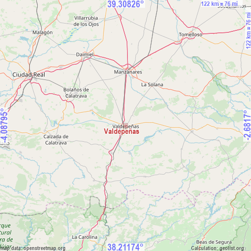
Valdepeñas GPS coordinates[2]
38° 45' 43.596" North, 3° 23' 5.388" West
| Map corner | latitude | longitude |
|---|---|---|
| Upper-left | 39.30826°, | -4.08795° |
| Center: | 38.76211°, | -3.38483° |
| Lower-right: | 38.21174°, | -2.6817° |
| Map W x H: | 121.9×121.9 km | = 75.7×75.7mi |
| max Lat: | 43.74134° ⇑83.5% North |
| Valdepeñas: | 38.76211° |
| min Lat: | ⇓16.5% South 27.64134° |
| min Long | Valdepeñas | max Long |
| -18.00367° | -3.38483° | 4.2899° |
| W 49.4%⇐ | ⇒50.6% E |
Elevation
Elevation of Valdepeñas is 714 m = 2343 ft, and this is 116 m = 381 ft above average elevation for this country.
| Max E: |
1682 m = 5518 ft | 44.3% |
| Valdepeñas | 714 m 2343 ft | |
| Avg. | 598 m = 1962 ft | |
Min E: |
0 m = 0 ft | 55.7% |
See also: Spain elevation on elevation.city.
Geographical zone
Valdepeñas is located in North temperate zone (between Tropic of Cancer and the Arctic Circle). Distance of this Northern Tropic circle is 1704 km =1058.8 mi to South.| Distance of | km | miles | from Valdepeñas |
|---|---|---|---|
| North Pole | 5697.1 | 3540 | to North |
| Arctic Circle | 3091.2 | 1920.8 | to North |
| Tropic Cancer | 1704 | 1058.8 | to South |
| Equator | 4309.9 | 2678 | to South |


Nearby cities:
15 places around Valdepeñas: (largest is in red/bold)
• Alcubillas
21.8 km =13.5 mi,  92°
92°
• Almagro
31.6 km =19.6 mi,  296°
296°
• Almuradiel
29.4 km =18.3 mi,  199°
199°
• Bolaños de Calatrava
29 km =18 mi, 303°
• Castellar de Santiago
26.5 km =16.5 mi,  159°
159°
• Cózar
29.3 km =18.2 mi,  112°
112°
• Granátula de Calatrava
31.3 km =19.4 mi,  277°
277°
• La Solana
23.9 km =14.9 mi,  32°
32°
• Manzanares
26.4 km =16.4 mi,  2°
2°
• Membrilla
23.6 km =14.7 mi,  8°
8°
• Moral de Calatrava
18.4 km =11.4 mi,  294°
294°
• San Carlos del Valle
15.4 km =9.6 mi,  53°
53°
• Santa Cruz de Mudela
15.1 km =9.4 mi,  208°
208°
• Torrenueva
13.8 km =8.6 mi,  171°
171°
• Viso del Marqués
30.9 km =19.2 mi, 210°
Sources, notices
• [Note1] Compared only with cities in Spain existing in our database
• [Src1] Map data: © OpenStreetMap contributors (CC-BY-SA)
• [Src2] Other city data from geonames.org with taken over terms of usage.
• [Src3] Geographical zone / Annual Mean Temperature by Robert A. Rohde @ Wikipedia
