Castellar de Santiago geodata
Castellar de Santiago (Castille-La Mancha) is a seat of a third-order administrative division; located in Spain in Europe/Madrid (GMT+2) time zone. With population of 2,175 people, there are 2064 cities with bigger population in this country. Compared to other cities in Spain, 85.4% of cities are located further ↑North; 50.7% of cities are located further ←West and 72.8% of cities have lower elevation than Castellar de Santiago. Note1
Administrative division(s):
- Level 1: Castille-La Mancha
- Level 2: Provincia de Ciudad Real
- Level 3: Castellar de Santiago
Current local time in Castellar de Santiago:
10:39 PM, ThursdayDifference from your time zone: hours


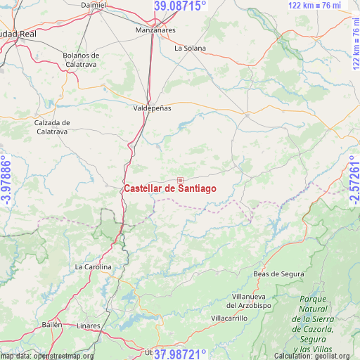
Castellar de Santiago GPS coordinates[2]
38° 32' 21.408" North, 3° 16' 32.628" West
| Map corner | latitude | longitude |
|---|---|---|
| Upper-left | 39.08715°, | -3.97886° |
| Center: | 38.53928°, | -3.27573° |
| Lower-right: | 37.98721°, | -2.57261° |
| Map W x H: | 122.3×122.3 km | = 76×76mi |
| max Lat: | 43.74134° ⇑85.4% North |
| Castellar de Santiago: | 38.53928° |
| min Lat: | ⇓14.6% South 27.64134° |
| min Long | Castellar de Sa | max Long |
| -18.00367° | -3.27573° | 4.2899° |
| W 50.7%⇐ | ⇒49.3% E |
Elevation
Elevation of Castellar de Santiago is 833 m = 2733 ft, and this is 235 m = 771 ft above average elevation for this country.
| Max E: |
1682 m = 5518 ft | 27.2% |
| Castellar de Santiago | 833 m 2733 ft | |
| Avg. | 598 m = 1962 ft | |
Min E: |
0 m = 0 ft | 72.8% |
See also: Spain elevation on elevation.city.
Geographical zone
Castellar de Santiago is located in North temperate zone (between Tropic of Cancer and the Arctic Circle). Distance of this Northern Tropic circle is 1679.2 km =1043.4 mi to South.| Distance of | km | miles | from Castellar de Santiago |
|---|---|---|---|
| North Pole | 5721.9 | 3555.4 | to North |
| Arctic Circle | 3116 | 1936.2 | to North |
| Tropic Cancer | 1679.2 | 1043.4 | to South |
| Equator | 4285.2 | 2662.7 | to South |


Nearby cities:
15 places around Castellar de Santiago: (largest is in red/bold)
• Alcubillas
26.8 km =16.7 mi,  27°
27°
• Aldeaquemada
16.4 km =10.2 mi,  210°
210°
• Almedina
29.5 km =18.3 mi,  71°
71°
• Almuradiel
19.5 km =12.1 mi,  261°
261°
• Cózar
22.4 km =13.9 mi,  52°
52°
• Infantes
31.7 km =19.7 mi, 46°
• Montizón
26.5 km =16.5 mi,  145°
145°
• Puebla del Príncipe
30.6 km =19 mi,  84°
84°
• Santa Cruz de Mudela
20.2 km =12.6 mi,  304°
304°
• Santa Elena
31.8 km =19.8 mi,  226°
226°
• Torre de Juan Abad
19.4 km =12.1 mi, 75°
• Torrenueva
13.5 km =8.4 mi,  325°
325°
• Valdepeñas
26.5 km =16.5 mi,  339°
339°
• Villamanrique
24.2 km =15 mi,  88°
88°
• Viso del Marqués
25.1 km =15.6 mi,  265°
265°
Sources, notices
• [Note1] Compared only with cities in Spain existing in our database
• [Src1] Map data: © OpenStreetMap contributors (CC-BY-SA)
• [Src2] Other city data from geonames.org with taken over terms of usage.
• [Src3] Geographical zone / Annual Mean Temperature by Robert A. Rohde @ Wikipedia
