San Carlos del Valle geodata
San Carlos del Valle (Castille-La Mancha) is a seat of a third-order administrative division; located in Spain in Europe/Madrid (GMT+2) time zone. With population of 1,215 people, there are 2713 cities with bigger population in this country. Compared to other cities in Spain, 82.8% of cities are located further ↑North; 51.1% of cities are located further ←West and 62.1% of cities have lower elevation than San Carlos del Valle. Note1
Administrative division(s):
- Level 1: Castille-La Mancha
- Level 2: Provincia de Ciudad Real
- Level 3: San Carlos del Valle


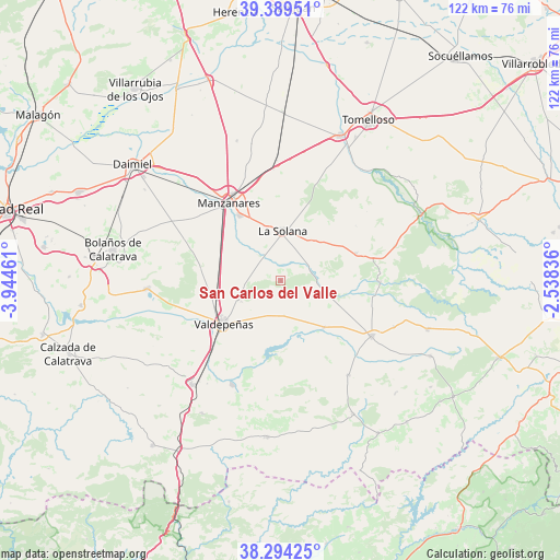
San Carlos del Valle GPS coordinates[2]
38° 50' 38.364" North, 3° 14' 29.328" West
| Map corner | latitude | longitude |
|---|---|---|
| Upper-left | 39.38951°, | -3.94461° |
| Center: | 38.84399°, | -3.24148° |
| Lower-right: | 38.29425°, | -2.53836° |
| Map W x H: | 121.8×121.8 km | = 75.7×75.7mi |
| max Lat: | 43.74134° ⇑82.8% North |
| San Carlos del Valle: | 38.84399° |
| min Lat: | ⇓17.2% South 27.64134° |
| min Long | San Carlos del | max Long |
| -18.00367° | -3.24148° | 4.2899° |
| W 51.1%⇐ | ⇒48.9% E |
Elevation
Elevation of San Carlos del Valle is 758 m = 2487 ft, and this is 160 m = 525 ft above average elevation for this country.
| Max E: |
1682 m = 5518 ft | 37.9% |
| San Carlos del Valle | 758 m 2487 ft | |
| Avg. | 598 m = 1962 ft | |
Min E: |
0 m = 0 ft | 62.1% |
See also: Spain elevation on elevation.city.
Geographical zone
San Carlos del Valle is located in North temperate zone (between Tropic of Cancer and the Arctic Circle). Distance of this Northern Tropic circle is 1713.1 km =1064.5 mi to South.| Distance of | km | miles | from San Carlos del Valle |
|---|---|---|---|
| North Pole | 5688 | 3534.4 | to North |
| Arctic Circle | 3082.1 | 1915.1 | to North |
| Tropic Cancer | 1713.1 | 1064.5 | to South |
| Equator | 4319 | 2683.7 | to South |


Nearby cities:
15 places around San Carlos del Valle: (largest is in red/bold)
• Alcubillas
13.7 km =8.5 mi,  137°
137°
• Alhambra
17.4 km =10.8 mi,  69°
69°
• Carrizosa
21.6 km =13.4 mi,  90°
90°
• Cózar
25 km =15.5 mi, 143°
• Fuenllana
26.4 km =16.4 mi,  111°
111°
• Infantes
23.2 km =14.4 mi,  120°
120°
• La Solana
11.1 km =6.9 mi,  1°
1°
• Llanos del Caudillo
31.9 km =19.8 mi,  342°
342°
• Manzanares
20.5 km =12.7 mi,  327°
327°
• Membrilla
16.7 km =10.4 mi, 328°
• Moral de Calatrava
29.2 km =18.1 mi,  266°
266°
• Santa Cruz de Mudela
29.7 km =18.5 mi,  221°
221°
• Torre de Juan Abad
32.9 km =20.4 mi,  151°
151°
• Torrenueva
25 km =15.5 mi,  204°
204°
• Valdepeñas
15.4 km =9.6 mi,  233°
233°
Sources, notices
• [Note1] Compared only with cities in Spain existing in our database
• [Src1] Map data: © OpenStreetMap contributors (CC-BY-SA)
• [Src2] Other city data from geonames.org with taken over terms of usage.
• [Src3] Geographical zone / Annual Mean Temperature by Robert A. Rohde @ Wikipedia
