Cózar geodata
Cózar (Castille-La Mancha) is a seat of a third-order administrative division; located in Spain in Europe/Madrid (GMT+2) time zone. With population of 1,305 people, there are 2639 cities with bigger population in this country. Compared to other cities in Spain, 84.6% of cities are located further ↑North; 53.2% of cities are located further ←West and 76% of cities have lower elevation than Cózar. Note1
Administrative division(s):
- Level 1: Castille-La Mancha
- Level 2: Provincia de Ciudad Real
- Level 3: Cózar


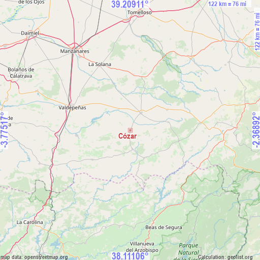
Cózar GPS coordinates[2]
38° 39' 43.884" North, 3° 4' 19.38" West
| Map corner | latitude | longitude |
|---|---|---|
| Upper-left | 39.20911°, | -3.77517° |
| Center: | 38.66219°, | -3.07205° |
| Lower-right: | 38.11106°, | -2.36892° |
| Map W x H: | 122.1×122.1 km | = 75.9×75.9mi |
| max Lat: | 43.74134° ⇑84.6% North |
| Cózar: | 38.66219° |
| min Lat: | ⇓15.4% South 27.64134° |
| min Long | Cózar | max Long |
| -18.00367° | -3.07205° | 4.2899° |
| W 53.2%⇐ | ⇒46.8% E |
Elevation
Elevation of Cózar is 860 m = 2822 ft, and this is 262 m = 860 ft above average elevation for this country.
| Max E: |
1682 m = 5518 ft | 24% |
| Cózar | 860 m 2822 ft | |
| Avg. | 598 m = 1962 ft | |
Min E: |
0 m = 0 ft | 76% |
See also: Spain elevation on elevation.city.
Geographical zone
Cózar is located in North temperate zone (between Tropic of Cancer and the Arctic Circle). Distance of this Northern Tropic circle is 1692.9 km =1051.9 mi to South.| Distance of | km | miles | from Cózar |
|---|---|---|---|
| North Pole | 5708.2 | 3546.9 | to North |
| Arctic Circle | 3102.3 | 1927.7 | to North |
| Tropic Cancer | 1692.9 | 1051.9 | to South |
| Equator | 4298.8 | 2671.1 | to South |


Nearby cities:
15 places around Cózar: (largest is in red/bold)
• Albaladejo
23.4 km =14.5 mi,  101°
101°
• Alcubillas
11.5 km =7.1 mi,  331°
331°
• Almedina
11.1 km =6.9 mi,  112°
112°
• Carrizosa
21.2 km =13.2 mi,  19°
19°
• Castellar de Santiago
22.4 km =13.9 mi,  232°
232°
• Fuenllana
14.4 km =8.9 mi,  43°
43°
• Infantes
9.8 km =6.1 mi,  32°
32°
• Montiel
18.5 km =11.5 mi,  77°
77°
• Puebla del Príncipe
16.5 km =10.3 mi,  129°
129°
• San Carlos del Valle
25 km =15.5 mi,  323°
323°
• Santa Cruz de los Cáñamos
18.1 km =11.2 mi, 98°
• Terrinches
20.8 km =12.9 mi, 106°
• Torre de Juan Abad
8.7 km =5.4 mi,  173°
173°
• Villahermosa
20 km =12.4 mi,  60°
60°
• Villamanrique
14.4 km =8.9 mi,  153°
153°
Sources, notices
• [Note1] Compared only with cities in Spain existing in our database
• [Src1] Map data: © OpenStreetMap contributors (CC-BY-SA)
• [Src2] Other city data from geonames.org with taken over terms of usage.
• [Src3] Geographical zone / Annual Mean Temperature by Robert A. Rohde @ Wikipedia
