Albacete geodata
Albacete (Castille-La Mancha) is a seat of a second-order administrative division; located in Spain in Europe/Madrid (GMT+2) time zone. With population of 169,716 people, there are 45 cities with bigger population in this country. Compared to other cities in Spain, 81% of cities are located further ↑North; 68.9% of cities are located further ←West and 53.4% of cities have lower elevation than Albacete. Note1
Administrative division(s):
- Level 1: Castille-La Mancha
- Level 2: Provincia de Albacete
- Level 3: Albacete


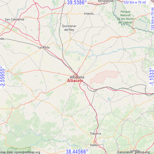
Albacete GPS coordinates[2]
38° 59' 39.264" North, 1° 51' 23.148" West
| Map corner | latitude | longitude |
|---|---|---|
| Upper-left | 39.5386°, | -2.55955° |
| Center: | 38.99424°, | -1.85643° |
| Lower-right: | 38.44566°, | -1.1533° |
| Map W x H: | 121.5×121.5 km | = 75.5×75.5mi |
| max Lat: | 43.74134° ⇑81% North |
| Albacete: | 38.99424° |
| min Lat: | ⇓19% South 27.64134° |
| min Long | Albacete | max Long |
| -18.00367° | -1.85643° | 4.2899° |
| W 68.9%⇐ | ⇒31.1% E |
Elevation
Elevation of Albacete is 695 m = 2280 ft, and this is 97 m = 318 ft above average elevation for this country.
| Max E: |
1682 m = 5518 ft | 46.6% |
| Albacete | 695 m 2280 ft | |
| Avg. | 598 m = 1962 ft | |
Min E: |
0 m = 0 ft | 53.4% |
See also: Albacete elevation on elevation.city.
Geographical zone
Albacete is located in North temperate zone (between Tropic of Cancer and the Arctic Circle). Distance of this Northern Tropic circle is 1729.8 km =1074.8 mi to South.| Distance of | km | miles | from Albacete |
|---|---|---|---|
| North Pole | 5671.3 | 3524 | to North |
| Arctic Circle | 3065.4 | 1904.8 | to North |
| Tropic Cancer | 1729.8 | 1074.8 | to South |
| Equator | 4335.8 | 2694.1 | to South |


Nearby cities:
15 places around Albacete: (largest is in red/bold)
• Balazote
28.3 km =17.6 mi,  244°
244°
• Barrax
30.4 km =18.9 mi,  280°
280°
• Casas de Juan Núñez
28.4 km =17.6 mi,  65°
65°
• Chinchilla de Monte Aragón
14.3 km =8.9 mi,  124°
124°
• Hoya-Gonzalo
26.2 km =16.3 mi,  98°
98°
• La Gineta
18 km =11.2 mi,  317°
317°
• Madrigueras
27 km =16.8 mi,  10°
10°
• Mahora
26.9 km =16.7 mi,  23°
23°
• Montalvos
23.6 km =14.7 mi, 324°
• Motilleja
22 km =13.7 mi, 16°
• Pozo-Cañada
23.7 km =14.7 mi,  153°
153°
• Pozohondo
30.8 km =19.1 mi,  188°
188°
• Pozuelo
29.5 km =18.3 mi,  225°
225°
• Tarazona de la Mancha
28.9 km =18 mi,  349°
349°
• Valdeganga
22 km =13.7 mi,  44°
44°
Sources, notices
• [Note1] Compared only with cities in Spain existing in our database
• [Src1] Map data: © OpenStreetMap contributors (CC-BY-SA)
• [Src2] Other city data from geonames.org with taken over terms of usage.
• [Src3] Geographical zone / Annual Mean Temperature by Robert A. Rohde @ Wikipedia
