Fuente de Cantos geodata
Fuente de Cantos (Extremadura) is a seat of a third-order administrative division; located in Spain in Europe/Madrid (GMT+2) time zone. With population of 4,952 people, there are 1318 cities with bigger population in this country. Compared to other cities in Spain, 87% of cities are located further ↑North; 89.4% of cities are located further →East and 54.3% of cities have higher elevation than Fuente de Cantos. Note1
Administrative division(s):
- Level 1: Extremadura
- Level 2: Provincia de Badajoz
- Level 3: Fuente de Cantos


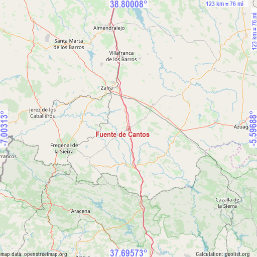
Fuente de Cantos GPS coordinates[2]
38° 15' 0" North, 6° 18' 0" West
| Map corner | latitude | longitude |
|---|---|---|
| Upper-left | 38.80008°, | -7.00313° |
| Center: | 38.25°, | -6.3° |
| Lower-right: | 37.69573°, | -5.59688° |
| Map W x H: | 122.8×122.8 km | = 76.3×76.3mi |
| max Lat: | 43.74134° ⇑87% North |
| Fuente de Cantos: | 38.25° |
| min Lat: | ⇓13% South 27.64134° |
| min Long | Fuente de Canto | max Long |
| -18.00367° | -6.3° | 4.2899° |
| W 10.6%⇐ | ⇒89.4% E |
Elevation
Elevation of Fuente de Cantos is 607 m = 1991 ft, and this is 9 m = 30 ft above average elevation for this country.
| Max E: |
1682 m = 5518 ft | 54.3% |
| Fuente de Cantos | 607 m 1991 ft | |
| Avg. | 598 m = 1962 ft | |
Min E: |
0 m = 0 ft | 45.7% |
See also: Spain elevation on elevation.city.
Geographical zone
Fuente de Cantos is located in North temperate zone (between Tropic of Cancer and the Arctic Circle). Distance of this Northern Tropic circle is 1647.1 km =1023.5 mi to South.| Distance of | km | miles | from Fuente de Cantos |
|---|---|---|---|
| North Pole | 5754.1 | 3575.4 | to North |
| Arctic Circle | 3148.2 | 1956.2 | to North |
| Tropic Cancer | 1647.1 | 1023.5 | to South |
| Equator | 4253 | 2642.7 | to South |


Nearby cities:
15 places around Fuente de Cantos: (largest is in red/bold)
• Alconera
22.1 km =13.7 mi,  318°
318°
• Atalaya
17.2 km =10.7 mi,  302°
302°
• Bienvenida
10.3 km =6.4 mi,  57°
57°
• Cabeza la Vaca
21.2 km =13.2 mi,  208°
208°
• Calera de León
16.9 km =10.5 mi,  189°
189°
• Calzadilla de Los Barros
5.7 km =3.5 mi,  345°
345°
• Medina de las Torres
12.7 km =7.9 mi, 316°
• Monesterio
18.8 km =11.7 mi,  171°
171°
• Montemolín
14.1 km =8.8 mi,  141°
141°
• Puebla de Sancho Pérez
18.8 km =11.7 mi,  332°
332°
• Usagre
16.1 km =10 mi,  46°
46°
• Valencia del Ventoso
14.7 km =9.1 mi,  277°
277°
• Valverde de Burguillos
22.3 km =13.9 mi,  292°
292°
• Villagarcía de la Torre
19.7 km =12.2 mi,  73°
73°
• Zafra
22 km =13.7 mi, 332°
Sources, notices
• [Note1] Compared only with cities in Spain existing in our database
• [Src1] Map data: © OpenStreetMap contributors (CC-BY-SA)
• [Src2] Other city data from geonames.org with taken over terms of usage.
• [Src3] Geographical zone / Annual Mean Temperature by Robert A. Rohde @ Wikipedia
