Totana geodata
Totana (Murcia) is a seat of a third-order administrative division; located in Spain in Europe/Madrid (GMT+2) time zone. With population of 29,211 people, there are 317 cities with bigger population in this country. Compared to other cities in Spain, 89.7% of cities are located further ↑North; 72.9% of cities are located further ←West and 77.6% of cities have higher elevation than Totana. Note1


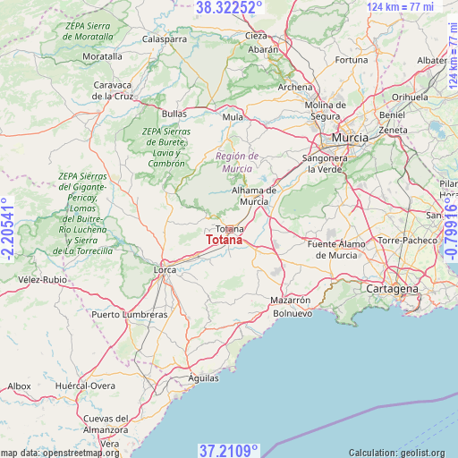
Totana GPS coordinates[2]
37° 46' 7.68" North, 1° 30' 8.244" West
| Map corner | latitude | longitude |
|---|---|---|
| Upper-left | 38.32252°, | -2.20541° |
| Center: | 37.7688°, | -1.50229° |
| Lower-right: | 37.2109°, | -0.79916° |
| Map W x H: | 123.6×123.6 km | = 76.8×76.8mi |
| max Lat: | 43.74134° ⇑89.7% North |
| Totana: | 37.7688° |
| min Lat: | ⇓10.3% South 27.64134° |
| min Long | Totana | max Long |
| -18.00367° | -1.50229° | 4.2899° |
| W 72.9%⇐ | ⇒27.1% E |
Elevation
Elevation of Totana is 262 m = 860 ft, and this is 336 m = 1102 ft below average elevation for this country.
| Max E: |
1682 m = 5518 ft | 77.6% |
| Avg. | 598 m = 1962 ft | |
| Totana | 262 m = 860 ft | |
Min E: |
0 m = 0 ft | 22.4% |
See also: Spain elevation on elevation.city.
Geographical zone
Totana is located in North temperate zone (between Tropic of Cancer and the Arctic Circle). Distance of this Northern Tropic circle is 1593.6 km =990.2 mi to South.| Distance of | km | miles | from Totana |
|---|---|---|---|
| North Pole | 5807.6 | 3608.7 | to North |
| Arctic Circle | 3201.7 | 1989.4 | to North |
| Tropic Cancer | 1593.6 | 990.2 | to South |
| Equator | 4199.5 | 2609.4 | to South |


Nearby cities:
15 places around Totana: (largest is in red/bold)
• Albudeite
30.7 km =19.1 mi,  19°
19°
• Alcantarilla
33.5 km =20.8 mi,  48°
48°
• Aledo
6.8 km =4.2 mi,  293°
293°
• Alhama de Murcia
11.4 km =7.1 mi,  36°
36°
• Campos del Río
32.8 km =20.4 mi, 23°
• Cazalla
19.8 km =12.3 mi,  227°
227°
• Fuente-Álamo de Murcia
29.7 km =18.5 mi,  99°
99°
• La Torrecilla
25.6 km =15.9 mi, 230°
• Librilla
18.4 km =11.4 mi, 44°
• Lorca
20.6 km =12.8 mi,  238°
238°
• Mazarrón
25 km =15.5 mi,  138°
138°
• Mula
30.3 km =18.8 mi,  2°
2°
• Pliego
24.5 km =15.2 mi,  359°
359°
• Sangonera la Verde
31.4 km =19.5 mi,  55°
55°
• Valladolises
33.3 km =20.7 mi,  88°
88°
Sources, notices
• [Note1] Compared only with cities in Spain existing in our database
• [Src1] Map data: © OpenStreetMap contributors (CC-BY-SA)
• [Src2] Other city data from geonames.org with taken over terms of usage.
• [Src3] Geographical zone / Annual Mean Temperature by Robert A. Rohde @ Wikipedia
