Alcantarilla geodata
Alcantarilla (Murcia) is a seat of a third-order administrative division; located in Spain in Europe/Madrid (GMT+2) time zone. With population of 41,084 people, there are 214 cities with bigger population in this country. Compared to other cities in Spain, 88.8% of cities are located further ↑North; 75.5% of cities are located further ←West and 89.3% of cities have higher elevation than Alcantarilla. Note1


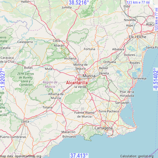
Alcantarilla GPS coordinates[2]
37° 58' 9.804" North, 1° 13' 1.704" West
| Map corner | latitude | longitude |
|---|---|---|
| Upper-left | 38.5216°, | -1.92027° |
| Center: | 37.96939°, | -1.21714° |
| Lower-right: | 37.413°, | -0.51402° |
| Map W x H: | 123.3×123.3 km | = 76.6×76.6mi |
| max Lat: | 43.74134° ⇑88.8% North |
| Alcantarilla: | 37.96939° |
| min Lat: | ⇓11.2% South 27.64134° |
| min Long | Alcantarilla | max Long |
| -18.00367° | -1.21714° | 4.2899° |
| W 75.5%⇐ | ⇒24.5% E |
Elevation
Elevation of Alcantarilla is 76 m = 249 ft, and this is 522 m = 1713 ft below average elevation for this country.
| Max E: |
1682 m = 5518 ft | 89.3% |
| Avg. | 598 m = 1962 ft | |
| Alcantarilla | 76 m = 249 ft | |
Min E: |
0 m = 0 ft | 10.7% |
See also: Alcantarilla elevation on elevation.city.
Geographical zone
Alcantarilla is located in North temperate zone (between Tropic of Cancer and the Arctic Circle). Distance of this Northern Tropic circle is 1615.9 km =1004.1 mi to South.| Distance of | km | miles | from Alcantarilla |
|---|---|---|---|
| North Pole | 5785.3 | 3594.8 | to North |
| Arctic Circle | 3179.4 | 1975.6 | to North |
| Tropic Cancer | 1615.9 | 1004.1 | to South |
| Equator | 4221.8 | 2623.3 | to South |


Nearby cities:
15 places around Alcantarilla: (largest is in red/bold)
• Albudeite
16.3 km =10.1 mi,  294°
294°
• Alguazas
9.8 km =6.1 mi,  342°
342°
• Barrio de San José Obrero
16.1 km =10 mi,  66°
66°
• Cabecicos
12.9 km =8 mi, 67°
• Campos del Río
14.2 km =8.8 mi,  303°
303°
• Ceuti
13.1 km =8.1 mi, 337°
• Cobatillas
15.6 km =9.7 mi,  52°
52°
• Esparragal
13.7 km =8.5 mi,  58°
58°
• Las Torres de Cotillas
6.9 km =4.3 mi, 341°
• Librilla
15.2 km =9.4 mi,  232°
232°
• Lorquí
12.9 km =8 mi,  346°
346°
• Molina de Segura
9.5 km =5.9 mi,  5°
5°
• Murcia
7.9 km =4.9 mi,  75°
75°
• Sangonera la Verde
4.6 km =2.9 mi,  169°
169°
• Santa Cruz
15.2 km =9.4 mi, 67°
Sources, notices
• [Note1] Compared only with cities in Spain existing in our database
• [Src1] Map data: © OpenStreetMap contributors (CC-BY-SA)
• [Src2] Other city data from geonames.org with taken over terms of usage.
• [Src3] Geographical zone / Annual Mean Temperature by Robert A. Rohde @ Wikipedia
