Alhama de Murcia geodata
Alhama de Murcia (Murcia) is a seat of a third-order administrative division; located in Spain in Europe/Madrid (GMT+2) time zone. With population of 19,860 people, there are 479 cities with bigger population in this country. Compared to other cities in Spain, 89.3% of cities are located further ↑North; 73.7% of cities are located further ←West and 81.1% of cities have higher elevation than Alhama de Murcia. Note1


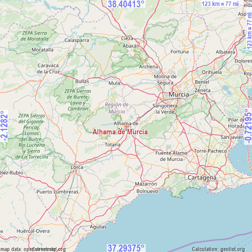
Alhama de Murcia GPS coordinates[2]
37° 51' 3.708" North, 1° 25' 30.252" West
| Map corner | latitude | longitude |
|---|---|---|
| Upper-left | 38.40413°, | -2.1282° |
| Center: | 37.85103°, | -1.42507° |
| Lower-right: | 37.29375°, | -0.72195° |
| Map W x H: | 123.5×123.5 km | = 76.7×76.7mi |
| max Lat: | 43.74134° ⇑89.3% North |
| Alhama de Murcia: | 37.85103° |
| min Lat: | ⇓10.7% South 27.64134° |
| min Long | Alhama de Murci | max Long |
| -18.00367° | -1.42507° | 4.2899° |
| W 73.7%⇐ | ⇒26.3% E |
Elevation
Elevation of Alhama de Murcia is 201 m = 659 ft, and this is 397 m = 1302 ft below average elevation for this country.
| Max E: |
1682 m = 5518 ft | 81.1% |
| Avg. | 598 m = 1962 ft | |
| Alhama de Murcia | 201 m = 659 ft | |
Min E: |
0 m = 0 ft | 18.9% |
See also: Spain elevation on elevation.city.
Geographical zone
Alhama de Murcia is located in North temperate zone (between Tropic of Cancer and the Arctic Circle). Distance of this Northern Tropic circle is 1602.7 km =995.9 mi to South.| Distance of | km | miles | from Alhama de Murcia |
|---|---|---|---|
| North Pole | 5798.4 | 3603 | to North |
| Arctic Circle | 3192.5 | 1983.7 | to North |
| Tropic Cancer | 1602.7 | 995.9 | to South |
| Equator | 4208.6 | 2615.1 | to South |


Nearby cities:
15 places around Alhama de Murcia: (largest is in red/bold)
• Albudeite
20.1 km =12.5 mi,  9°
9°
• Alcantarilla
22.5 km =14 mi,  54°
54°
• Aledo
14.5 km =9 mi,  243°
243°
• Alguazas
27.2 km =16.9 mi,  34°
34°
• Campos del Río
21.9 km =13.6 mi,  16°
16°
• Ceuti
28.5 km =17.7 mi, 27°
• Fuente-Álamo de Murcia
26.5 km =16.5 mi,  122°
122°
• Las Torres de Cotillas
25.4 km =15.8 mi,  39°
39°
• Librilla
7.3 km =4.5 mi,  57°
57°
• Molina de Segura
29.6 km =18.4 mi, 40°
• Mula
21.9 km =13.6 mi,  344°
344°
• Pliego
16.9 km =10.5 mi, 335°
• Sangonera la Verde
20.9 km =13 mi,  65°
65°
• Totana
11.4 km =7.1 mi,  216°
216°
• Valladolises
27.7 km =17.2 mi,  107°
107°
Sources, notices
• [Note1] Compared only with cities in Spain existing in our database
• [Src1] Map data: © OpenStreetMap contributors (CC-BY-SA)
• [Src2] Other city data from geonames.org with taken over terms of usage.
• [Src3] Geographical zone / Annual Mean Temperature by Robert A. Rohde @ Wikipedia
