Librilla geodata
Librilla (Murcia) is a seat of a third-order administrative division; located in Spain in Europe/Madrid (GMT+2) time zone. With population of 4,145 people, there are 1444 cities with bigger population in this country. Compared to other cities in Spain, 89.2% of cities are located further ↑North; 74.2% of cities are located further ←West and 82.6% of cities have higher elevation than Librilla. Note1


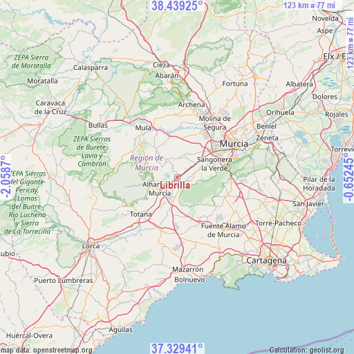
Librilla GPS coordinates[2]
37° 53' 11.112" North, 1° 21' 20.052" West
| Map corner | latitude | longitude |
|---|---|---|
| Upper-left | 38.43925°, | -2.0587° |
| Center: | 37.88642°, | -1.35557° |
| Lower-right: | 37.32941°, | -0.65245° |
| Map W x H: | 123.4×123.4 km | = 76.7×76.7mi |
| max Lat: | 43.74134° ⇑89.2% North |
| Librilla: | 37.88642° |
| min Lat: | ⇓10.8% South 27.64134° |
| min Long | Librilla | max Long |
| -18.00367° | -1.35557° | 4.2899° |
| W 74.2%⇐ | ⇒25.8% E |
Elevation
Elevation of Librilla is 175 m = 574 ft, and this is 423 m = 1388 ft below average elevation for this country.
| Max E: |
1682 m = 5518 ft | 82.6% |
| Avg. | 598 m = 1962 ft | |
| Librilla | 175 m = 574 ft | |
Min E: |
0 m = 0 ft | 17.4% |
See also: Spain elevation on elevation.city.
Geographical zone
Librilla is located in North temperate zone (between Tropic of Cancer and the Arctic Circle). Distance of this Northern Tropic circle is 1606.7 km =998.4 mi to South.| Distance of | km | miles | from Librilla |
|---|---|---|---|
| North Pole | 5794.5 | 3600.5 | to North |
| Arctic Circle | 3188.6 | 1981.3 | to North |
| Tropic Cancer | 1606.7 | 998.4 | to South |
| Equator | 4212.6 | 2617.6 | to South |


Nearby cities:
15 places around Librilla: (largest is in red/bold)
• Albudeite
16.1 km =10 mi,  350°
350°
• Alcantarilla
15.2 km =9.4 mi,  52°
52°
• Aledo
21.8 km =13.5 mi,  241°
241°
• Alguazas
20.7 km =12.9 mi,  26°
26°
• Alhama de Murcia
7.3 km =4.5 mi, 237°
• Campos del Río
17 km =10.6 mi,  0°
0°
• Ceuti
22.5 km =14 mi,  18°
18°
• Las Torres de Cotillas
18.7 km =11.6 mi, 32°
• Lorquí
23.7 km =14.7 mi, 22°
• Molina de Segura
22.8 km =14.2 mi, 34°
• Mula
20.8 km =12.9 mi,  325°
325°
• Murcia
22.7 km =14.1 mi,  60°
60°
• Pliego
17.4 km =10.8 mi,  311°
311°
• Sangonera la Verde
13.8 km =8.6 mi,  70°
70°
• Totana
18.4 km =11.4 mi,  224°
224°
Sources, notices
• [Note1] Compared only with cities in Spain existing in our database
• [Src1] Map data: © OpenStreetMap contributors (CC-BY-SA)
• [Src2] Other city data from geonames.org with taken over terms of usage.
• [Src3] Geographical zone / Annual Mean Temperature by Robert A. Rohde @ Wikipedia
