Pliego geodata
Pliego (Murcia) is a seat of a third-order administrative division; located in Spain in Europe/Madrid (GMT+2) time zone. With population of 3,543 people, there are 1579 cities with bigger population in this country. Compared to other cities in Spain, 88.6% of cities are located further ↑North; 72.8% of cities are located further ←West and 68.8% of cities have higher elevation than Pliego. Note1


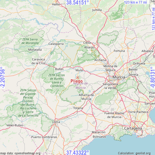
Pliego GPS coordinates[2]
37° 59' 22.056" North, 1° 30' 15.984" West
| Map corner | latitude | longitude |
|---|---|---|
| Upper-left | 38.54151°, | -2.20756° |
| Center: | 37.98946°, | -1.50444° |
| Lower-right: | 37.43322°, | -0.80131° |
| Map W x H: | 123.2×123.2 km | = 76.6×76.6mi |
| max Lat: | 43.74134° ⇑88.6% North |
| Pliego: | 37.98946° |
| min Lat: | ⇓11.4% South 27.64134° |
| min Long | Pliego | max Long |
| -18.00367° | -1.50444° | 4.2899° |
| W 72.8%⇐ | ⇒27.2% E |
Elevation
Elevation of Pliego is 402 m = 1319 ft, and this is 196 m = 643 ft below average elevation for this country.
| Max E: |
1682 m = 5518 ft | 68.8% |
| Avg. | 598 m = 1962 ft | |
| Pliego | 402 m = 1319 ft | |
Min E: |
0 m = 0 ft | 31.2% |
See also: Spain elevation on elevation.city.
Geographical zone
Pliego is located in North temperate zone (between Tropic of Cancer and the Arctic Circle). Distance of this Northern Tropic circle is 1618.1 km =1005.4 mi to South.| Distance of | km | miles | from Pliego |
|---|---|---|---|
| North Pole | 5783 | 3593.4 | to North |
| Arctic Circle | 3177.1 | 1974.2 | to North |
| Tropic Cancer | 1618.1 | 1005.4 | to South |
| Equator | 4224 | 2624.7 | to South |


Nearby cities:
15 places around Pliego: (largest is in red/bold)
• Albudeite
11.2 km =7 mi,  66°
66°
• Aledo
22.6 km =14 mi,  195°
195°
• Alguazas
23.4 km =14.5 mi, 72°
• Alhama de Murcia
16.9 km =10.5 mi,  155°
155°
• Archena
22.8 km =14.2 mi,  51°
51°
• Blanca
23.9 km =14.9 mi,  28°
28°
• Bullas
16 km =9.9 mi,  293°
293°
• Campos del Río
14.4 km =8.9 mi, 67°
• Ceuti
22.4 km =13.9 mi,  63°
63°
• Las Torres de Cotillas
23.4 km =14.5 mi,  79°
79°
• Librilla
17.4 km =10.8 mi,  131°
131°
• Mula
5.9 km =3.7 mi,  12°
12°
• Ojós
22.5 km =14 mi,  38°
38°
• Ricote
21.9 km =13.6 mi, 33°
• Ulea
22.7 km =14.1 mi, 42°
Sources, notices
• [Note1] Compared only with cities in Spain existing in our database
• [Src1] Map data: © OpenStreetMap contributors (CC-BY-SA)
• [Src2] Other city data from geonames.org with taken over terms of usage.
• [Src3] Geographical zone / Annual Mean Temperature by Robert A. Rohde @ Wikipedia
