Añora geodata
Añora (Andalusia) is a populated place; located in Spain in Europe/Madrid (GMT+2) time zone. With population of 1,521 people, there are 2450 cities with bigger population in this country. Compared to other cities in Spain, 86.1% of cities are located further ↑North; 71.1% of cities are located further →East and 53.2% of cities have higher elevation than Añora. Note1


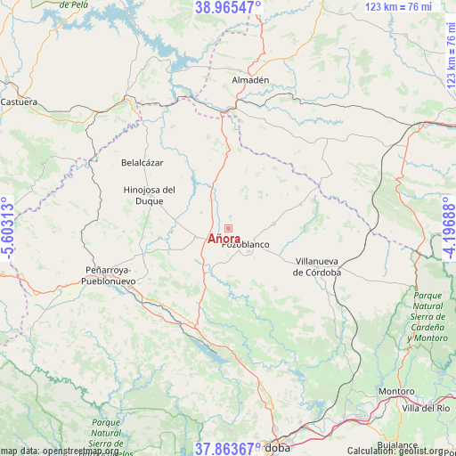
Añora GPS coordinates[2]
38° 25' 0.012" North, 4° 54' 0" West
| Map corner | latitude | longitude |
|---|---|---|
| Upper-left | 38.96547°, | -5.60313° |
| Center: | 38.41667°, | -4.9° |
| Lower-right: | 37.86367°, | -4.19688° |
| Map W x H: | 122.5×122.5 km | = 76.1×76.1mi |
| max Lat: | 43.74134° ⇑86.1% North |
| Añora: | 38.41667° |
| min Lat: | ⇓13.9% South 27.64134° |
| min Long | Añora | max Long |
| -18.00367° | -4.9° | 4.2899° |
| W 28.9%⇐ | ⇒71.1% E |
Elevation
Elevation of Añora is 621 m = 2037 ft, and this is 23 m = 75 ft above average elevation for this country.
| Max E: |
1682 m = 5518 ft | 53.2% |
| Añora | 621 m 2037 ft | |
| Avg. | 598 m = 1962 ft | |
Min E: |
0 m = 0 ft | 46.8% |
See also: Spain elevation on elevation.city.
Geographical zone
Añora is located in North temperate zone (between Tropic of Cancer and the Arctic Circle). Distance of this Northern Tropic circle is 1665.6 km =1035 mi to South.| Distance of | km | miles | from Añora |
|---|---|---|---|
| North Pole | 5735.5 | 3563.9 | to North |
| Arctic Circle | 3129.6 | 1944.6 | to North |
| Tropic Cancer | 1665.6 | 1035 | to South |
| Equator | 4271.5 | 2654.2 | to South |


Nearby cities:
15 places around Añora: (largest is in red/bold)
• Alamillo
30.6 km =19 mi,  18°
18°
• Alcaracejos
6.9 km =4.3 mi,  237°
237°
• Belalcázar
29.2 km =18.1 mi,  307°
307°
• Dos Torres
3.7 km =2.3 mi,  0°
0°
• El Viso
8.6 km =5.3 mi,  329°
329°
• Espiel
26.2 km =16.3 mi,  202°
202°
• Fuente la Lancha
11.6 km =7.2 mi,  270°
270°
• Hinojosa del Duque
23.4 km =14.5 mi,  293°
293°
• Pedroche
12 km =7.5 mi,  83°
83°
• Pozoblanco
6.1 km =3.8 mi,  132°
132°
• Santa Eufemia
20.4 km =12.7 mi, 0°
• Torrecampo
21.1 km =13.1 mi,  74°
74°
• Villanueva de Córdoba
25.9 km =16.1 mi,  113°
113°
• Villanueva del Duque
9.5 km =5.9 mi,  246°
246°
• Villaralto
8.1 km =5 mi,  297°
297°
Sources, notices
• [Note1] Compared only with cities in Spain existing in our database
• [Src1] Map data: © OpenStreetMap contributors (CC-BY-SA)
• [Src2] Other city data from geonames.org with taken over terms of usage.
• [Src3] Geographical zone / Annual Mean Temperature by Robert A. Rohde @ Wikipedia
