Pozoblanco geodata
Pozoblanco (Andalusia) is a seat of a third-order administrative division; located in Spain in Europe/Madrid (GMT+2) time zone. With population of 17,669 people, there are 536 cities with bigger population in this country. Compared to other cities in Spain, 86.3% of cities are located further ↑North; 70.4% of cities are located further →East and 50% of cities have lower elevation than Pozoblanco. Note1


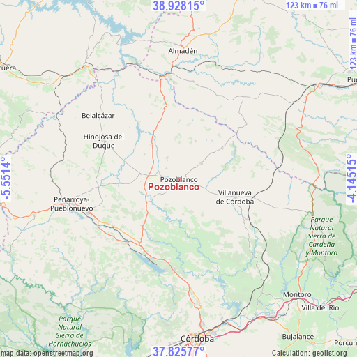
Pozoblanco GPS coordinates[2]
38° 22' 44.616" North, 4° 50' 53.772" West
| Map corner | latitude | longitude |
|---|---|---|
| Upper-left | 38.92815°, | -5.5514° |
| Center: | 38.37906°, | -4.84827° |
| Lower-right: | 37.82577°, | -4.14515° |
| Map W x H: | 122.6×122.6 km | = 76.2×76.2mi |
| max Lat: | 43.74134° ⇑86.3% North |
| Pozoblanco: | 38.37906° |
| min Lat: | ⇓13.7% South 27.64134° |
| min Long | Pozoblanco | max Long |
| -18.00367° | -4.84827° | 4.2899° |
| W 29.6%⇐ | ⇒70.4% E |
Elevation
Elevation of Pozoblanco is 657 m = 2156 ft, and this is 59 m = 194 ft above average elevation for this country.
| Max E: |
1682 m = 5518 ft | 50% |
| Pozoblanco | 657 m 2156 ft | |
| Avg. | 598 m = 1962 ft | |
Min E: |
0 m = 0 ft | 50% |
See also: Spain elevation on elevation.city.
Geographical zone
Pozoblanco is located in North temperate zone (between Tropic of Cancer and the Arctic Circle). Distance of this Northern Tropic circle is 1661.4 km =1032.3 mi to South.| Distance of | km | miles | from Pozoblanco |
|---|---|---|---|
| North Pole | 5739.7 | 3566.5 | to North |
| Arctic Circle | 3133.8 | 1947.3 | to North |
| Tropic Cancer | 1661.4 | 1032.3 | to South |
| Equator | 4267.4 | 2651.6 | to South |


Nearby cities:
15 places around Pozoblanco: (largest is in red/bold)
• Alcaracejos
10.3 km =6.4 mi,  272°
272°
• Añora
6.1 km =3.8 mi,  312°
312°
• Dos Torres
9.1 km =5.7 mi,  330°
330°
• El Viso
14.6 km =9.1 mi,  322°
322°
• Espiel
24.7 km =15.3 mi,  216°
216°
• Fuente la Lancha
16.7 km =10.4 mi,  284°
284°
• Hinojosa del Duque
29.3 km =18.2 mi,  297°
297°
• Obejo
27.7 km =17.2 mi,  171°
171°
• Pedroche
9.2 km =5.7 mi,  53°
53°
• Santa Eufemia
25 km =15.5 mi,  349°
349°
• Torrecampo
18.6 km =11.6 mi,  58°
58°
• Villaharta
27.7 km =17.2 mi,  189°
189°
• Villanueva de Córdoba
20.1 km =12.5 mi,  108°
108°
• Villanueva del Duque
13.2 km =8.2 mi, 272°
• Villaralto
14.2 km =8.8 mi, 303°
Sources, notices
• [Note1] Compared only with cities in Spain existing in our database
• [Src1] Map data: © OpenStreetMap contributors (CC-BY-SA)
• [Src2] Other city data from geonames.org with taken over terms of usage.
• [Src3] Geographical zone / Annual Mean Temperature by Robert A. Rohde @ Wikipedia
