Guia geodata
Guia (Canary Islands) is a populated place; located in Spain in Atlantic/Canary (GMT+1) time zone. With population of 14,031 people, there are 658 cities with bigger population in this country. Compared to other cities in Spain, 99.4% of cities are located further ↑North; 99.1% of cities are located further →East and 82.3% of cities have higher elevation than Guia. Note1
Administrative division(s):
- Level 1: Canary Islands
- Level 2: Provincia de Las Palmas
- Level 3: Gáldar


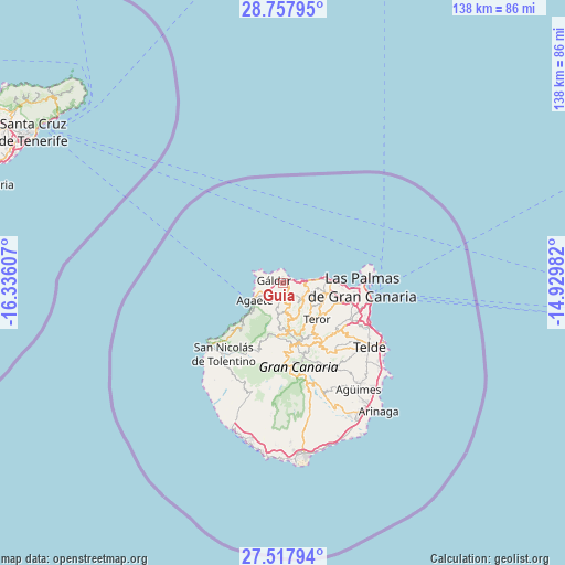
Guia GPS coordinates[2]
28° 8' 23.064" North, 15° 37' 58.584" West
| Map corner | latitude | longitude |
|---|---|---|
| Upper-left | 28.75795°, | -16.33607° |
| Center: | 28.13974°, | -15.63294° |
| Lower-right: | 27.51794°, | -14.92982° |
| Map W x H: | 137.9×137.9 km | = 85.7×85.7mi |
| max Lat: | 43.74134° ⇑99.4% North |
| Guia: | 28.13974° |
| min Lat: | ⇓0.6% South 27.64134° |
| min Long | Guia | max Long |
| -18.00367° | -15.63294° | 4.2899° |
| W 0.9%⇐ | ⇒99.1% E |
Elevation
Elevation of Guia is 181 m = 594 ft, and this is 417 m = 1368 ft below average elevation for this country.
| Max E: |
1682 m = 5518 ft | 82.3% |
| Avg. | 598 m = 1962 ft | |
| Guia | 181 m = 594 ft | |
Min E: |
0 m = 0 ft | 17.7% |
See also: Spain elevation on elevation.city.
Geographical zone
Guia is located in North temperate zone (between Tropic of Cancer and the Arctic Circle). Distance of this Northern Tropic circle is 522.9 km =324.9 mi to South.| Distance of | km | miles | from Guia |
|---|---|---|---|
| North Pole | 6878.2 | 4273.9 | to North |
| Arctic Circle | 4272.3 | 2654.7 | to North |
| Tropic Cancer | 522.9 | 324.9 | to South |
| Equator | 3128.8 | 1944.1 | to South |


Nearby cities:
15 places around Guia: (largest is in red/bold)
• Agaete
7.9 km =4.9 mi,  236°
236°
• Artenara
13.3 km =8.3 mi,  185°
185°
• Arucas
11 km =6.8 mi,  101°
101°
• Firgas
7.8 km =4.8 mi,  117°
117°
• Gáldar
1.9 km =1.2 mi,  295°
295°
• Las Palmas de Gran Canaria
22 km =13.7 mi, 101°
• Moya
5.9 km =3.7 mi, 122°
• San Bartolomé de Tirajana
24.6 km =15.3 mi,  166°
166°
• San Nicolás
22.2 km =13.8 mi,  220°
220°
• Santa Brígida
17.4 km =10.8 mi,  133°
133°
• Tejeda
16.2 km =10.1 mi, 173°
• Teror
12 km =7.5 mi,  136°
136°
• Valleseco
12.1 km =7.5 mi,  152°
152°
• Valsequillo de Gran Canaria
21.7 km =13.5 mi, 142°
• Vega de San Mateo
17.5 km =10.9 mi, 146°
Sources, notices
• [Note1] Compared only with cities in Spain existing in our database
• [Src1] Map data: © OpenStreetMap contributors (CC-BY-SA)
• [Src2] Other city data from geonames.org with taken over terms of usage.
• [Src3] Geographical zone / Annual Mean Temperature by Robert A. Rohde @ Wikipedia
