Tejeda geodata
Tejeda (Canary Islands) is a populated place; located in Spain in Atlantic/Canary (GMT+1) time zone. With population of 2,338 people, there are 1980 cities with bigger population in this country. Compared to other cities in Spain, 99.8% of cities are located further ↑North; 99% of cities are located further →East and 90.8% of cities have lower elevation than Tejeda. Note1
Administrative division(s):
- Level 1: Canary Islands
- Level 2: Provincia de Las Palmas
- Level 3: Tejeda


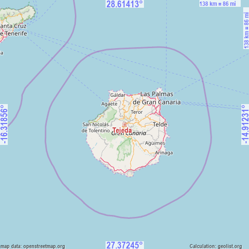
Tejeda GPS coordinates[2]
27° 59' 42.288" North, 15° 36' 55.548" West
| Map corner | latitude | longitude |
|---|---|---|
| Upper-left | 28.61413°, | -16.31856° |
| Center: | 27.99508°, | -15.61543° |
| Lower-right: | 27.37245°, | -14.91231° |
| Map W x H: | 138.1×138.1 km | = 85.8×85.8mi |
| max Lat: | 43.74134° ⇑99.8% North |
| Tejeda: | 27.99508° |
| min Lat: | ⇓0.2% South 27.64134° |
| min Long | Tejeda | max Long |
| -18.00367° | -15.61543° | 4.2899° |
| W 1%⇐ | ⇒99% E |
Elevation
Elevation of Tejeda is 1046 m = 3432 ft, and this is 448 m = 1470 ft above average elevation for this country.
| Max E: |
1682 m = 5518 ft | 9.2% |
| Tejeda | 1046 m 3432 ft | |
| Avg. | 598 m = 1962 ft | |
Min E: |
0 m = 0 ft | 90.8% |
See also: Spain elevation on elevation.city.
Geographical zone
Tejeda is located in North temperate zone (between Tropic of Cancer and the Arctic Circle). Distance of this Northern Tropic circle is 506.8 km =314.9 mi to South.| Distance of | km | miles | from Tejeda |
|---|---|---|---|
| North Pole | 6894.3 | 4283.9 | to North |
| Arctic Circle | 4288.4 | 2664.7 | to North |
| Tropic Cancer | 506.8 | 314.9 | to South |
| Equator | 3112.8 | 1934.2 | to South |


Nearby cities:
15 places around Tejeda: (largest is in red/bold)
• Agaete
14.3 km =8.9 mi,  324°
324°
• Artenara
4.2 km =2.6 mi,  312°
312°
• Arucas
16.6 km =10.3 mi,  33°
33°
• Firgas
13.5 km =8.4 mi,  22°
22°
• Guia
16.2 km =10.1 mi,  353°
353°
• Mogán
16.4 km =10.2 mi,  221°
221°
• Moya
13.3 km =8.3 mi,  13°
13°
• San Bartolomé de Tirajana
8.8 km =5.5 mi,  152°
152°
• San Nicolás
16.3 km =10.1 mi,  267°
267°
• Santa Brígida
11.7 km =7.3 mi,  69°
69°
• Santa Lucía
11.8 km =7.3 mi,  141°
141°
• Teror
9.8 km =6.1 mi,  41°
41°
• Valleseco
6.6 km =4.1 mi, 35°
• Valsequillo de Gran Canaria
11.7 km =7.3 mi,  95°
95°
• Vega de San Mateo
8.2 km =5.1 mi,  79°
79°
Sources, notices
• [Note1] Compared only with cities in Spain existing in our database
• [Src1] Map data: © OpenStreetMap contributors (CC-BY-SA)
• [Src2] Other city data from geonames.org with taken over terms of usage.
• [Src3] Geographical zone / Annual Mean Temperature by Robert A. Rohde @ Wikipedia
