Sorvilán geodata
Sorvilán (Andalusia) is a seat of a third-order administrative division; located in Spain in Europe/Madrid (GMT+2) time zone. With population of 746 people, there are 3313 cities with bigger population in this country. Compared to other cities in Spain, 96.8% of cities are located further ↑North; 50.8% of cities are located further ←West and 66.8% of cities have lower elevation than Sorvilán. Note1


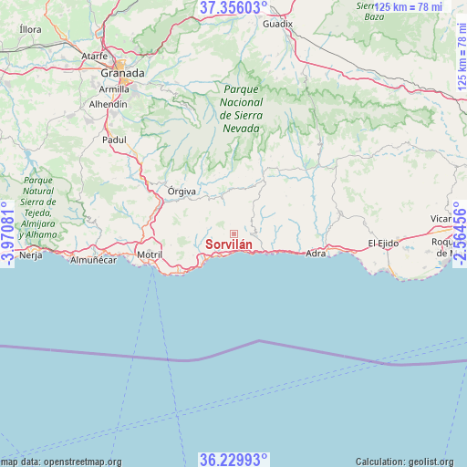
Sorvilán GPS coordinates[2]
36° 47' 42.18" North, 3° 16' 3.684" West
| Map corner | latitude | longitude |
|---|---|---|
| Upper-left | 37.35603°, | -3.97081° |
| Center: | 36.79505°, | -3.26769° |
| Lower-right: | 36.22993°, | -2.56456° |
| Map W x H: | 125.2×125.2 km | = 77.8×77.8mi |
| max Lat: | 43.74134° ⇑96.8% North |
| Sorvilán: | 36.79505° |
| min Lat: | ⇓3.2% South 27.64134° |
| min Long | Sorvilán | max Long |
| -18.00367° | -3.26769° | 4.2899° |
| W 50.8%⇐ | ⇒49.2% E |
Elevation
Elevation of Sorvilán is 790 m = 2592 ft, and this is 192 m = 630 ft above average elevation for this country.
| Max E: |
1682 m = 5518 ft | 33.2% |
| Sorvilán | 790 m 2592 ft | |
| Avg. | 598 m = 1962 ft | |
Min E: |
0 m = 0 ft | 66.8% |
See also: Spain elevation on elevation.city.
Geographical zone
Sorvilán is located in North temperate zone (between Tropic of Cancer and the Arctic Circle). Distance of this Northern Tropic circle is 1485.3 km =922.9 mi to South.| Distance of | km | miles | from Sorvilán |
|---|---|---|---|
| North Pole | 5915.8 | 3675.9 | to North |
| Arctic Circle | 3309.9 | 2056.7 | to North |
| Tropic Cancer | 1485.3 | 922.9 | to South |
| Equator | 4091.2 | 2542.2 | to South |


Nearby cities:
15 places around Sorvilán: (largest is in red/bold)
• Albondón
6.2 km =3.9 mi,  54°
54°
• Albuñol
5.6 km =3.5 mi,  93°
93°
• Almegíjar
12.3 km =7.6 mi,  345°
345°
• Busquístar
16.1 km =10 mi, 351°
• Castell de Ferro
11 km =6.8 mi,  225°
225°
• Cástaras
15.2 km =9.4 mi,  4°
4°
• Gualchos
12.3 km =7.6 mi,  242°
242°
• Juviles
17.5 km =10.9 mi,  12°
12°
• Lobras
15.6 km =9.7 mi,  18°
18°
• Lújar
12.2 km =7.6 mi,  266°
266°
• Murtas
17.3 km =10.7 mi, 54°
• Pampaneira
18.1 km =11.2 mi,  332°
332°
• Polopos
2.7 km =1.7 mi, 269°
• Pórtugos
16.8 km =10.4 mi, 346°
• Rubite
7.3 km =4.5 mi,  282°
282°
Sources, notices
• [Note1] Compared only with cities in Spain existing in our database
• [Src1] Map data: © OpenStreetMap contributors (CC-BY-SA)
• [Src2] Other city data from geonames.org with taken over terms of usage.
• [Src3] Geographical zone / Annual Mean Temperature by Robert A. Rohde @ Wikipedia
