Castell de Ferro geodata
Castell de Ferro (Andalusia) is a populated place; located in Spain in Europe/Madrid (GMT+2) time zone. With population of 2,964 people, there are 1733 cities with bigger population in this country. Compared to other cities in Spain, 97.4% of cities are located further ↑North; 50.2% of cities are located further →East and 95.8% of cities have higher elevation than Castell de Ferro. Note1


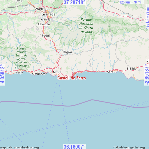
Castell de Ferro GPS coordinates[2]
36° 43' 32.484" North, 3° 21' 18" West
| Map corner | latitude | longitude |
|---|---|---|
| Upper-left | 37.28718°, | -4.05812° |
| Center: | 36.72569°, | -3.355° |
| Lower-right: | 36.16007°, | -2.65187° |
| Map W x H: | 125.3×125.3 km | = 77.9×77.9mi |
| max Lat: | 43.74134° ⇑97.4% North |
| Castell de Ferro: | 36.72569° |
| min Lat: | ⇓2.6% South 27.64134° |
| min Long | Castell de Ferr | max Long |
| -18.00367° | -3.355° | 4.2899° |
| W 49.8%⇐ | ⇒50.2% E |
Elevation
Elevation of Castell de Ferro is 21 m = 69 ft, and this is 577 m = 1893 ft below average elevation for this country.
| Max E: |
1682 m = 5518 ft | 95.8% |
| Avg. | 598 m = 1962 ft | |
| Castell de Ferro | 21 m = 69 ft | |
Min E: |
0 m = 0 ft | 4.2% |
See also: Spain elevation on elevation.city.
Geographical zone
Castell de Ferro is located in North temperate zone (between Tropic of Cancer and the Arctic Circle). Distance of this Northern Tropic circle is 1477.6 km =918.1 mi to South.| Distance of | km | miles | from Castell de Ferro |
|---|---|---|---|
| North Pole | 5923.5 | 3680.7 | to North |
| Arctic Circle | 3317.7 | 2061.5 | to North |
| Tropic Cancer | 1477.6 | 918.1 | to South |
| Equator | 4083.5 | 2537.4 | to South |


Nearby cities:
15 places around Castell de Ferro: (largest is in red/bold)
• Albondón
17.1 km =10.6 mi,  48°
48°
• Albuñol
15.3 km =9.5 mi,  61°
61°
• Almegíjar
20.2 km =12.6 mi,  13°
13°
• Carataunas
22.3 km =13.9 mi,  347°
347°
• El Varadero
14.9 km =9.3 mi,  269°
269°
• Gualchos
3.8 km =2.4 mi,  303°
303°
• Lújar
8.2 km =5.1 mi,  327°
327°
• Motril
14.8 km =9.2 mi,  280°
280°
• Polopos
9.2 km =5.7 mi,  33°
33°
• Rubite
9.3 km =5.8 mi,  3°
3°
• Salobreña
20.8 km =12.9 mi, 275°
• Sorvilán
11 km =6.8 mi, 45°
• Torrenueva
12.2 km =7.6 mi,  258°
258°
• Vélez de Benaudalla
18.6 km =11.6 mi,  309°
309°
• Órgiva
20.6 km =12.8 mi,  342°
342°
Sources, notices
• [Note1] Compared only with cities in Spain existing in our database
• [Src1] Map data: © OpenStreetMap contributors (CC-BY-SA)
• [Src2] Other city data from geonames.org with taken over terms of usage.
• [Src3] Geographical zone / Annual Mean Temperature by Robert A. Rohde @ Wikipedia
