Gualchos geodata
Gualchos (Andalusia) is a seat of a third-order administrative division; located in Spain in Europe/Madrid (GMT+2) time zone. With population of 2,559 people, there are 1880 cities with bigger population in this country. Compared to other cities in Spain, 97.2% of cities are located further ↑North; 50.7% of cities are located further →East and 71.6% of cities have higher elevation than Gualchos. Note1


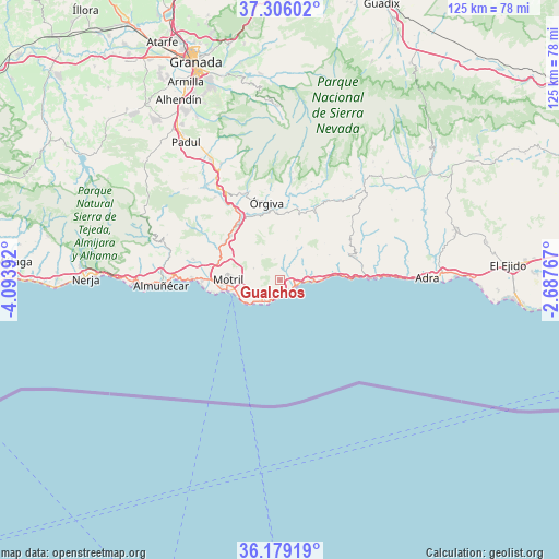
Gualchos GPS coordinates[2]
36° 44' 40.812" North, 3° 23' 26.844" West
| Map corner | latitude | longitude |
|---|---|---|
| Upper-left | 37.30602°, | -4.09392° |
| Center: | 36.74467°, | -3.39079° |
| Lower-right: | 36.17919°, | -2.68767° |
| Map W x H: | 125.3×125.3 km | = 77.9×77.9mi |
| max Lat: | 43.74134° ⇑97.2% North |
| Gualchos: | 36.74467° |
| min Lat: | ⇓2.8% South 27.64134° |
| min Long | Gualchos | max Long |
| -18.00367° | -3.39079° | 4.2899° |
| W 49.3%⇐ | ⇒50.7% E |
Elevation
Elevation of Gualchos is 355 m = 1165 ft, and this is 243 m = 797 ft below average elevation for this country.
| Max E: |
1682 m = 5518 ft | 71.6% |
| Avg. | 598 m = 1962 ft | |
| Gualchos | 355 m = 1165 ft | |
Min E: |
0 m = 0 ft | 28.4% |
See also: Spain elevation on elevation.city.
Geographical zone
Gualchos is located in North temperate zone (between Tropic of Cancer and the Arctic Circle). Distance of this Northern Tropic circle is 1479.7 km =919.4 mi to South.| Distance of | km | miles | from Gualchos |
|---|---|---|---|
| North Pole | 5921.4 | 3679.4 | to North |
| Arctic Circle | 3315.5 | 2060.2 | to North |
| Tropic Cancer | 1479.7 | 919.4 | to South |
| Equator | 4085.6 | 2538.7 | to South |


Nearby cities:
15 places around Gualchos: (largest is in red/bold)
• Albondón
18.4 km =11.4 mi,  59°
59°
• Albuñol
17.4 km =10.8 mi,  72°
72°
• Almegíjar
19.3 km =12 mi,  24°
24°
• Carataunas
19.8 km =12.3 mi,  355°
355°
• Castell de Ferro
3.8 km =2.4 mi,  123°
123°
• El Varadero
11.9 km =7.4 mi,  259°
259°
• Lújar
5 km =3.1 mi,  346°
346°
• Motril
11.3 km =7 mi,  273°
273°
• Polopos
9.9 km =6.2 mi, 56°
• Rubite
8.1 km =5 mi,  27°
27°
• Salobreña
17.5 km =10.9 mi, 269°
• Sorvilán
12.3 km =7.6 mi, 62°
• Torrenueva
9.9 km =6.2 mi,  242°
242°
• Vélez de Benaudalla
14.8 km =9.2 mi,  311°
311°
• Órgiva
17.8 km =11.1 mi, 350°
Sources, notices
• [Note1] Compared only with cities in Spain existing in our database
• [Src1] Map data: © OpenStreetMap contributors (CC-BY-SA)
• [Src2] Other city data from geonames.org with taken over terms of usage.
• [Src3] Geographical zone / Annual Mean Temperature by Robert A. Rohde @ Wikipedia
