Nigüelas geodata
Nigüelas (Andalusia) is a seat of a third-order administrative division; located in Spain in Europe/Madrid (GMT+2) time zone. With population of 924 people, there are 3046 cities with bigger population in this country. Compared to other cities in Spain, 95.5% of cities are located further ↑North; 52.8% of cities are located further →East and 83.2% of cities have lower elevation than Nigüelas. Note1


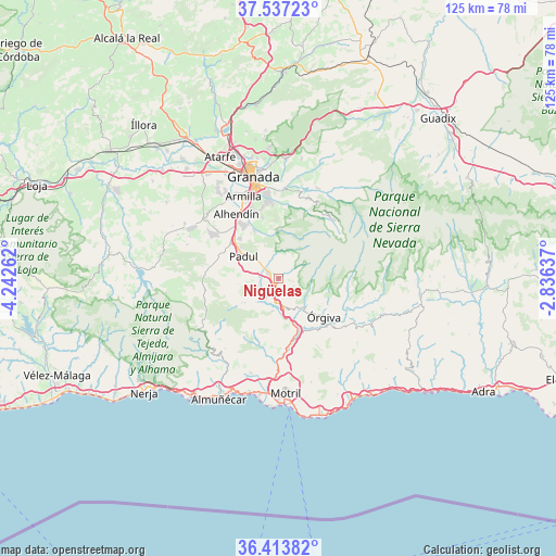
Nigüelas GPS coordinates[2]
36° 58' 39.36" North, 3° 32' 22.164" West
| Map corner | latitude | longitude |
|---|---|---|
| Upper-left | 37.53723°, | -4.24262° |
| Center: | 36.9776°, | -3.53949° |
| Lower-right: | 36.41382°, | -2.83637° |
| Map W x H: | 124.9×124.9 km | = 77.6×77.6mi |
| max Lat: | 43.74134° ⇑95.5% North |
| Nigüelas: | 36.9776° |
| min Lat: | ⇓4.5% South 27.64134° |
| min Long | Nigüelas | max Long |
| -18.00367° | -3.53949° | 4.2899° |
| W 47.2%⇐ | ⇒52.8% E |
Elevation
Elevation of Nigüelas is 930 m = 3051 ft, and this is 332 m = 1089 ft above average elevation for this country.
| Max E: |
1682 m = 5518 ft | 16.8% |
| Nigüelas | 930 m 3051 ft | |
| Avg. | 598 m = 1962 ft | |
Min E: |
0 m = 0 ft | 83.2% |
See also: Spain elevation on elevation.city.
Geographical zone
Nigüelas is located in North temperate zone (between Tropic of Cancer and the Arctic Circle). Distance of this Northern Tropic circle is 1505.6 km =935.5 mi to South.| Distance of | km | miles | from Nigüelas |
|---|---|---|---|
| North Pole | 5895.5 | 3663.3 | to North |
| Arctic Circle | 3289.7 | 2044.1 | to North |
| Tropic Cancer | 1505.6 | 935.5 | to South |
| Equator | 4111.5 | 2554.8 | to South |


Nearby cities:
15 places around Nigüelas: (largest is in red/bold)
• Albuñuelas
9.9 km =6.2 mi,  236°
236°
• Capileira
16.2 km =10.1 mi,  96°
96°
• Carataunas
13.2 km =8.2 mi,  117°
117°
• Cáñar
11.4 km =7.1 mi, 119°
• Dílar
11.9 km =7.4 mi,  332°
332°
• Dúrcal
2.6 km =1.6 mi,  295°
295°
• Gójar
15.3 km =9.5 mi,  337°
337°
• Lanjarón
8.3 km =5.2 mi,  142°
142°
• Otura
14.9 km =9.3 mi, 325°
• Padul
9.3 km =5.8 mi, 303°
• Pampaneira
16.4 km =10.2 mi, 104°
• Soportújar
13.1 km =8.1 mi,  114°
114°
• Vélez de Benaudalla
16.3 km =10.1 mi,  172°
172°
• Zubia
16.2 km =10.1 mi,  345°
345°
• Órgiva
13.2 km =8.2 mi,  129°
129°
Sources, notices
• [Note1] Compared only with cities in Spain existing in our database
• [Src1] Map data: © OpenStreetMap contributors (CC-BY-SA)
• [Src2] Other city data from geonames.org with taken over terms of usage.
• [Src3] Geographical zone / Annual Mean Temperature by Robert A. Rohde @ Wikipedia
