Escorca geodata
Escorca (Balearic Islands) is a seat of a third-order administrative division; located in Spain in Europe/Madrid (GMT+2) time zone. With population of 293 people, there are 4534 cities with bigger population in this country. Compared to other cities in Spain, 72.6% of cities are located further ↑North; 97.9% of cities are located further ←West and 52.3% of cities have lower elevation than Escorca. Note1


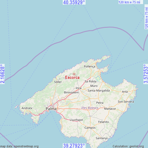
Escorca GPS coordinates[2]
39° 49' 16.968" North, 2° 52' 9.876" East
| Map corner | latitude | longitude |
|---|---|---|
| Upper-left | 40.35929°, | 2.16628° |
| Center: | 39.82138°, | 2.86941° |
| Lower-right: | 39.27923°, | 3.57253° |
| Map W x H: | 120.1×120.1 km | = 74.6×74.6mi |
| max Lat: | 43.74134° ⇑72.6% North |
| Escorca: | 39.82138° |
| min Lat: | ⇓27.4% South 27.64134° |
| min Long | Escorca | max Long |
| -18.00367° | 2.86941° | 4.2899° |
| W 97.9%⇐ | ⇒2.1% E |
Elevation
Elevation of Escorca is 682 m = 2238 ft, and this is 84 m = 276 ft above average elevation for this country.
| Max E: |
1682 m = 5518 ft | 47.7% |
| Escorca | 682 m 2238 ft | |
| Avg. | 598 m = 1962 ft | |
Min E: |
0 m = 0 ft | 52.3% |
See also: Spain elevation on elevation.city.
Geographical zone
Escorca is located in North temperate zone (between Tropic of Cancer and the Arctic Circle). Distance of this Northern Tropic circle is 1821.8 km =1132 mi to South.| Distance of | km | miles | from Escorca |
|---|---|---|---|
| North Pole | 5579.3 | 3466.8 | to North |
| Arctic Circle | 2973.5 | 1847.6 | to North |
| Tropic Cancer | 1821.8 | 1132 | to South |
| Equator | 4427.7 | 2751.2 | to South |


Nearby cities:
15 places around Escorca: (largest is in red/bold)
• Alaró
14.6 km =9.1 mi,  207°
207°
• Binissalem
15.1 km =9.4 mi,  188°
188°
• Búger
12 km =7.5 mi,  125°
125°
• Campanet
9.7 km =6 mi,  122°
122°
• Consell
17.7 km =11 mi,  195°
195°
• Fornalutx
11.8 km =7.3 mi,  248°
248°
• Inca
11.7 km =7.3 mi,  162°
162°
• Lloseta
11.4 km =7.1 mi,  181°
181°
• Llubí
17.9 km =11.1 mi,  139°
139°
• Mancor de la Vall
8 km =5 mi, 177°
• Pollença
14 km =8.7 mi,  63°
63°
• Port de Sóller
15 km =9.3 mi,  259°
259°
• Selva
7.8 km =4.8 mi, 160°
• Sóller
14.5 km =9 mi, 245°
• sa Pobla
14.4 km =8.9 mi,  113°
113°
Sources, notices
• [Note1] Compared only with cities in Spain existing in our database
• [Src1] Map data: © OpenStreetMap contributors (CC-BY-SA)
• [Src2] Other city data from geonames.org with taken over terms of usage.
• [Src3] Geographical zone / Annual Mean Temperature by Robert A. Rohde @ Wikipedia
