Almussafes geodata
Almussafes (Valencia) is a seat of a third-order administrative division; located in Spain in Europe/Madrid (GMT+2) time zone. With population of 7,459 people, there are 983 cities with bigger population in this country. Compared to other cities in Spain, 78.8% of cities are located further ↑North; 82.9% of cities are located further ←West and 98.9% of cities have higher elevation than Almussafes. Note1


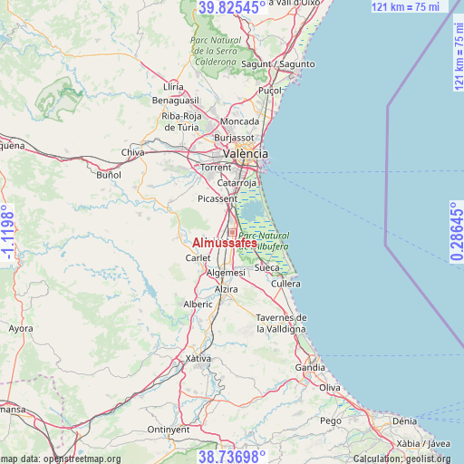
Almussafes GPS coordinates[2]
39° 16' 59.988" North, 0° 25' 0.012" West
| Map corner | latitude | longitude |
|---|---|---|
| Upper-left | 39.82545°, | -1.1198° |
| Center: | 39.28333°, | -0.41667° |
| Lower-right: | 38.73698°, | 0.28645° |
| Map W x H: | 121×121 km | = 75.2×75.2mi |
| max Lat: | 43.74134° ⇑78.8% North |
| Almussafes: | 39.28333° |
| min Lat: | ⇓21.2% South 27.64134° |
| min Long | Almussafes | max Long |
| -18.00367° | -0.41667° | 4.2899° |
| W 82.9%⇐ | ⇒17.1% E |
Elevation
Elevation of Almussafes is 8 m = 26 ft, and this is 590 m = 1936 ft below average elevation for this country.
| Max E: |
1682 m = 5518 ft | 98.9% |
| Avg. | 598 m = 1962 ft | |
| Almussafes | 8 m = 26 ft | |
Min E: |
0 m = 0 ft | 1.1% |
See also: Spain elevation on elevation.city.
Geographical zone
Almussafes is located in North temperate zone (between Tropic of Cancer and the Arctic Circle). Distance of this Northern Tropic circle is 1762 km =1094.9 mi to South.| Distance of | km | miles | from Almussafes |
|---|---|---|---|
| North Pole | 5639.2 | 3504 | to North |
| Arctic Circle | 3033.3 | 1884.8 | to North |
| Tropic Cancer | 1762 | 1094.9 | to South |
| Equator | 4367.9 | 2714.1 | to South |


Nearby cities:
15 places around Almussafes: (largest is in red/bold)
• Albalat de la Ribera
9.7 km =6 mi,  162°
162°
• Alcàsser
9.7 km =6 mi,  345°
345°
• Alfarp
11.5 km =7.1 mi,  270°
270°
• Algemesí
10.5 km =6.5 mi,  189°
189°
• Alginet
4.7 km =2.9 mi,  246°
246°
• Benicull de Xúquer
11.5 km =7.1 mi,  165°
165°
• Benifaió
0.8 km =0.5 mi,  278°
278°
• Beniparrell
11.1 km =6.9 mi,  0°
0°
• Carlet
11 km =6.8 mi,  235°
235°
• Guadassuar
12 km =7.5 mi,  206°
206°
• Picassent
9.6 km =6 mi,  337°
337°
• Polinyà de Xúquer
10.2 km =6.3 mi, 155°
• Riola
11.7 km =7.3 mi,  142°
142°
• Silla
8.8 km =5.5 mi, 2°
• Sollana
3 km =1.9 mi,  100°
100°
Sources, notices
• [Note1] Compared only with cities in Spain existing in our database
• [Src1] Map data: © OpenStreetMap contributors (CC-BY-SA)
• [Src2] Other city data from geonames.org with taken over terms of usage.
• [Src3] Geographical zone / Annual Mean Temperature by Robert A. Rohde @ Wikipedia
