Benitachell geodata
Benitachell (Valencia) is a populated place; located in Spain in Europe/Madrid (GMT+2) time zone. With population of 3,630 people, there are 1555 cities with bigger population in this country. Compared to other cities in Spain, 83.8% of cities are located further ↑North; 87.7% of cities are located further ←West and 84.2% of cities have higher elevation than Benitachell. Note1
Administrative division(s):
- Level 1: Valencia
- Level 2: Provincia de Alicante
- Level 3: Benitachell/Poble Nou de Benitatxell, el


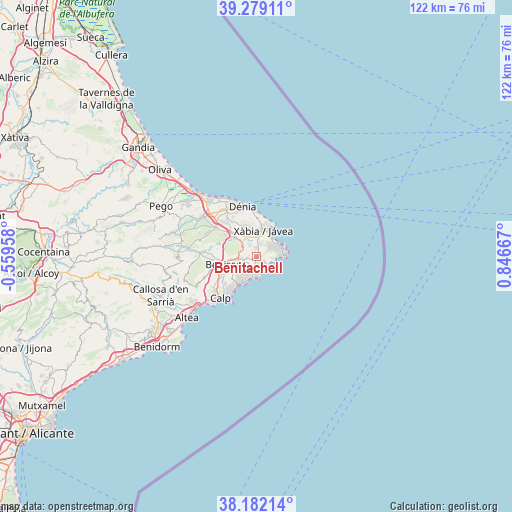
Benitachell GPS coordinates[2]
38° 43' 57.828" North, 0° 8' 36.744" East
| Map corner | latitude | longitude |
|---|---|---|
| Upper-left | 39.27911°, | -0.55958° |
| Center: | 38.73273°, | 0.14354° |
| Lower-right: | 38.18214°, | 0.84667° |
| Map W x H: | 122×122 km | = 75.8×75.8mi |
| max Lat: | 43.74134° ⇑83.8% North |
| Benitachell: | 38.73273° |
| min Lat: | ⇓16.2% South 27.64134° |
| min Long | Benitachell | max Long |
| -18.00367° | 0.14354° | 4.2899° |
| W 87.7%⇐ | ⇒12.3% E |
Elevation
Elevation of Benitachell is 153 m = 502 ft, and this is 445 m = 1460 ft below average elevation for this country.
| Max E: |
1682 m = 5518 ft | 84.2% |
| Avg. | 598 m = 1962 ft | |
| Benitachell | 153 m = 502 ft | |
Min E: |
0 m = 0 ft | 15.8% |
See also: Spain elevation on elevation.city.
Geographical zone
Benitachell is located in North temperate zone (between Tropic of Cancer and the Arctic Circle). Distance of this Northern Tropic circle is 1700.8 km =1056.8 mi to South.| Distance of | km | miles | from Benitachell |
|---|---|---|---|
| North Pole | 5700.4 | 3542.1 | to North |
| Arctic Circle | 3094.5 | 1922.8 | to North |
| Tropic Cancer | 1700.8 | 1056.8 | to South |
| Equator | 4306.7 | 2676.1 | to South |


Nearby cities:
15 places around Benitachell: (largest is in red/bold)
• Alcalalí
16 km =9.9 mi,  277°
277°
• Beniarbeig
16.1 km =10 mi,  308°
308°
• Benidoleig
16.5 km =10.3 mi,  293°
293°
• Benissa
8.5 km =5.3 mi,  256°
256°
• Calp
13 km =8.1 mi,  221°
221°
• Denia
12.5 km =7.8 mi,  344°
344°
• Gata de Gorgos
6.9 km =4.3 mi, 312°
• Jalón
13.5 km =8.4 mi,  273°
273°
• Javea
6 km =3.7 mi,  19°
19°
• Moraira
5 km =3.1 mi,  188°
188°
• Ondara
15.2 km =9.4 mi, 314°
• Pedreguer
11.6 km =7.2 mi, 305°
• Senija
8.8 km =5.5 mi, 266°
• Teulada
3.5 km =2.2 mi, 263°
• els Poblets
17.1 km =10.6 mi,  321°
321°
Sources, notices
• [Note1] Compared only with cities in Spain existing in our database
• [Src1] Map data: © OpenStreetMap contributors (CC-BY-SA)
• [Src2] Other city data from geonames.org with taken over terms of usage.
• [Src3] Geographical zone / Annual Mean Temperature by Robert A. Rohde @ Wikipedia
