Moraira geodata
Moraira (Valencia) is a populated place; located in Spain in Europe/Madrid (GMT+2) time zone. With population of 1,845 people, there are 2263 cities with bigger population in this country. Compared to other cities in Spain, 84.3% of cities are located further ↑North; 87.6% of cities are located further ←West and 96.6% of cities have higher elevation than Moraira. Note1


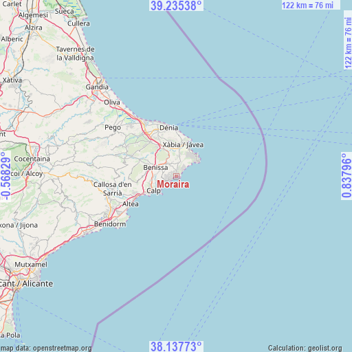
Moraira GPS coordinates[2]
38° 41' 19.176" North, 0° 8' 5.424" East
| Map corner | latitude | longitude |
|---|---|---|
| Upper-left | 39.23538°, | -0.56829° |
| Center: | 38.68866°, | 0.13484° |
| Lower-right: | 38.13773°, | 0.83796° |
| Map W x H: | 122×122 km | = 75.8×75.8mi |
| max Lat: | 43.74134° ⇑84.3% North |
| Moraira: | 38.68866° |
| min Lat: | ⇓15.7% South 27.64134° |
| min Long | Moraira | max Long |
| -18.00367° | 0.13484° | 4.2899° |
| W 87.6%⇐ | ⇒12.4% E |
Elevation
Elevation of Moraira is 17 m = 56 ft, and this is 581 m = 1906 ft below average elevation for this country.
| Max E: |
1682 m = 5518 ft | 96.6% |
| Avg. | 598 m = 1962 ft | |
| Moraira | 17 m = 56 ft | |
Min E: |
0 m = 0 ft | 3.4% |
See also: Spain elevation on elevation.city.
Geographical zone
Moraira is located in North temperate zone (between Tropic of Cancer and the Arctic Circle). Distance of this Northern Tropic circle is 1695.9 km =1053.8 mi to South.| Distance of | km | miles | from Moraira |
|---|---|---|---|
| North Pole | 5705.3 | 3545.1 | to North |
| Arctic Circle | 3099.4 | 1925.9 | to North |
| Tropic Cancer | 1695.9 | 1053.8 | to South |
| Equator | 4301.8 | 2673 | to South |


Nearby cities:
15 places around Moraira: (largest is in red/bold)
• Alcalalí
16.7 km =10.4 mi,  294°
294°
• Altea
19 km =11.8 mi,  238°
238°
• Benidoleig
18.4 km =11.4 mi,  309°
309°
• Benissa
8 km =5 mi, 291°
• Benitachell
5 km =3.1 mi,  8°
8°
• Calp
9.2 km =5.7 mi, 238°
• Denia
17.1 km =10.6 mi,  351°
351°
• Gata de Gorgos
10.5 km =6.5 mi,  335°
335°
• Jalón
13.9 km =8.6 mi, 294°
• Javea
10.9 km =6.8 mi, 14°
• Ondara
18.6 km =11.6 mi,  326°
326°
• Parcent
18.4 km =11.4 mi, 289°
• Pedreguer
14.5 km =9 mi,  323°
323°
• Senija
9.2 km =5.7 mi,  298°
298°
• Teulada
5.3 km =3.3 mi, 329°
Sources, notices
• [Note1] Compared only with cities in Spain existing in our database
• [Src1] Map data: © OpenStreetMap contributors (CC-BY-SA)
• [Src2] Other city data from geonames.org with taken over terms of usage.
• [Src3] Geographical zone / Annual Mean Temperature by Robert A. Rohde @ Wikipedia
