Igualeja geodata
Igualeja (Andalusia) is a seat of a third-order administrative division; located in Spain in Europe/Madrid (GMT+2) time zone. With population of 1,052 people, there are 2879 cities with bigger population in this country. Compared to other cities in Spain, 97.7% of cities are located further ↑North; 74% of cities are located further →East and 54.8% of cities have lower elevation than Igualeja. Note1


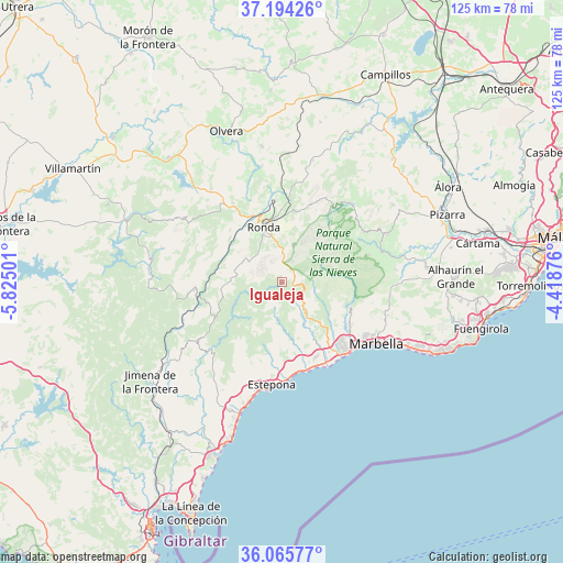
Igualeja GPS coordinates[2]
36° 37' 55.488" North, 5° 7' 18.768" West
| Map corner | latitude | longitude |
|---|---|---|
| Upper-left | 37.19426°, | -5.82501° |
| Center: | 36.63208°, | -5.12188° |
| Lower-right: | 36.06577°, | -4.41876° |
| Map W x H: | 125.5×125.5 km | = 78×78mi |
| max Lat: | 43.74134° ⇑97.7% North |
| Igualeja: | 36.63208° |
| min Lat: | ⇓2.3% South 27.64134° |
| min Long | Igualeja | max Long |
| -18.00367° | -5.12188° | 4.2899° |
| W 26%⇐ | ⇒74% E |
Elevation
Elevation of Igualeja is 708 m = 2323 ft, and this is 110 m = 361 ft above average elevation for this country.
| Max E: |
1682 m = 5518 ft | 45.2% |
| Igualeja | 708 m 2323 ft | |
| Avg. | 598 m = 1962 ft | |
Min E: |
0 m = 0 ft | 54.8% |
See also: Spain elevation on elevation.city.
Geographical zone
Igualeja is located in North temperate zone (between Tropic of Cancer and the Arctic Circle). Distance of this Northern Tropic circle is 1467.2 km =911.7 mi to South.| Distance of | km | miles | from Igualeja |
|---|---|---|---|
| North Pole | 5934 | 3687.2 | to North |
| Arctic Circle | 3328.1 | 2068 | to North |
| Tropic Cancer | 1467.2 | 911.7 | to South |
| Equator | 4073.1 | 2530.9 | to South |


Nearby cities:
15 places around Igualeja: (largest is in red/bold)
• Algatocín
15.2 km =9.4 mi,  244°
244°
• Alpandeire
7.2 km =4.5 mi,  271°
271°
• Atajate
11.1 km =6.9 mi, 274°
• Benahavís
13.8 km =8.6 mi,  150°
150°
• Benalauría
13.1 km =8.1 mi,  251°
251°
• Benaoján
15.1 km =9.4 mi,  309°
309°
• Cartajima
3.2 km =2 mi,  297°
297°
• Faraján
6.2 km =3.9 mi, 254°
• Genalguacil
14 km =8.7 mi,  226°
226°
• Jimera de Líbar
13.7 km =8.5 mi,  278°
278°
• Jubrique
11.2 km =7 mi, 228°
• Júzcar
4.4 km =2.7 mi,  258°
258°
• Parauta
2.8 km =1.7 mi,  346°
346°
• Pujerra
3.3 km =2.1 mi, 229°
• Ronda
12.9 km =8 mi,  341°
341°
Sources, notices
• [Note1] Compared only with cities in Spain existing in our database
• [Src1] Map data: © OpenStreetMap contributors (CC-BY-SA)
• [Src2] Other city data from geonames.org with taken over terms of usage.
• [Src3] Geographical zone / Annual Mean Temperature by Robert A. Rohde @ Wikipedia
