Júzcar geodata
Júzcar (Andalusia) is a seat of a third-order administrative division; located in Spain in Europe/Madrid (GMT+2) time zone. With population of 193 people, there are 5085 cities with bigger population in this country. Compared to other cities in Spain, 97.7% of cities are located further ↑North; 74.6% of cities are located further →East and 51.3% of cities have higher elevation than Júzcar. Note1


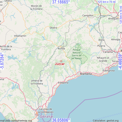
Júzcar GPS coordinates[2]
36° 37' 27.912" North, 5° 10' 10.956" West
| Map corner | latitude | longitude |
|---|---|---|
| Upper-left | 37.18665°, | -5.87284° |
| Center: | 36.62442°, | -5.16971° |
| Lower-right: | 36.05806°, | -4.46659° |
| Map W x H: | 125.5×125.5 km | = 78×78mi |
| max Lat: | 43.74134° ⇑97.7% North |
| Júzcar: | 36.62442° |
| min Lat: | ⇓2.3% South 27.64134° |
| min Long | Júzcar | max Long |
| -18.00367° | -5.16971° | 4.2899° |
| W 25.4%⇐ | ⇒74.6% E |
Elevation
Elevation of Júzcar is 645 m = 2116 ft, and this is 47 m = 154 ft above average elevation for this country.
| Max E: |
1682 m = 5518 ft | 51.3% |
| Júzcar | 645 m 2116 ft | |
| Avg. | 598 m = 1962 ft | |
Min E: |
0 m = 0 ft | 48.7% |
See also: Spain elevation on elevation.city.
Geographical zone
Júzcar is located in North temperate zone (between Tropic of Cancer and the Arctic Circle). Distance of this Northern Tropic circle is 1466.3 km =911.1 mi to South.| Distance of | km | miles | from Júzcar |
|---|---|---|---|
| North Pole | 5934.8 | 3687.7 | to North |
| Arctic Circle | 3328.9 | 2068.5 | to North |
| Tropic Cancer | 1466.3 | 911.1 | to South |
| Equator | 4072.3 | 2530.4 | to South |


Nearby cities:
15 places around Júzcar: (largest is in red/bold)
• Algatocín
11 km =6.8 mi,  239°
239°
• Alpandeire
3.1 km =1.9 mi,  290°
290°
• Atajate
7 km =4.3 mi,  284°
284°
• Benalauría
8.8 km =5.5 mi,  247°
247°
• Benaoján
12.9 km =8 mi,  325°
325°
• Benarrabá
12.5 km =7.8 mi,  229°
229°
• Cartajima
2.7 km =1.7 mi,  30°
30°
• Faraján
1.9 km =1.2 mi, 243°
• Genalguacil
10.6 km =6.6 mi,  213°
213°
• Igualeja
4.4 km =2.7 mi,  78°
78°
• Jimera de Líbar
9.8 km =6.1 mi, 287°
• Jubrique
7.8 km =4.8 mi, 211°
• Parauta
5.1 km =3.2 mi,  45°
45°
• Pujerra
2.2 km =1.4 mi,  126°
126°
• Ronda
13.1 km =8.1 mi,  1°
1°
Sources, notices
• [Note1] Compared only with cities in Spain existing in our database
• [Src1] Map data: © OpenStreetMap contributors (CC-BY-SA)
• [Src2] Other city data from geonames.org with taken over terms of usage.
• [Src3] Geographical zone / Annual Mean Temperature by Robert A. Rohde @ Wikipedia
