San Nicolás geodata
San Nicolás (Canary Islands) is a populated place; located in Spain in Atlantic/Canary (GMT+1) time zone. With population of 7,950 people, there are 941 cities with bigger population in this country. Compared to other cities in Spain, 99.8% of cities are located further ↑North; 99.1% of cities are located further →East and 90.5% of cities have higher elevation than San Nicolás. Note1
Administrative division(s):
- Level 1: Canary Islands
- Level 2: Provincia de Las Palmas
- Level 3: Aldea de San Nicolás, La


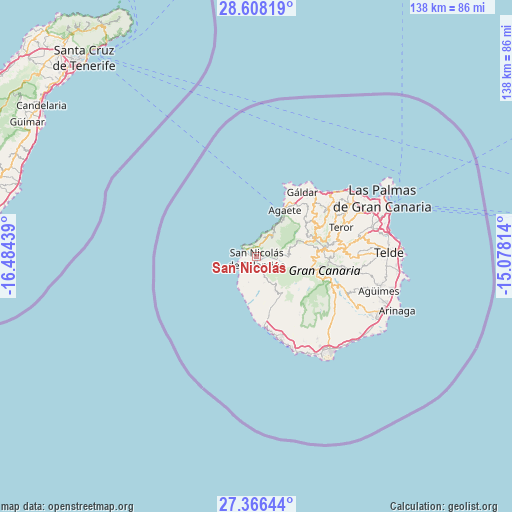
San Nicolás GPS coordinates[2]
27° 59' 20.76" North, 15° 46' 52.536" West
| Map corner | latitude | longitude |
|---|---|---|
| Upper-left | 28.60819°, | -16.48439° |
| Center: | 27.9891°, | -15.78126° |
| Lower-right: | 27.36644°, | -15.07814° |
| Map W x H: | 138.1×138.1 km | = 85.8×85.8mi |
| max Lat: | 43.74134° ⇑99.8% North |
| San Nicolás: | 27.9891° |
| min Lat: | ⇓0.2% South 27.64134° |
| min Long | San Nicolás | max Long |
| -18.00367° | -15.78126° | 4.2899° |
| W 0.9%⇐ | ⇒99.1% E |
Elevation
Elevation of San Nicolás is 57 m = 187 ft, and this is 541 m = 1775 ft below average elevation for this country.
| Max E: |
1682 m = 5518 ft | 90.5% |
| Avg. | 598 m = 1962 ft | |
| San Nicolás | 57 m = 187 ft | |
Min E: |
0 m = 0 ft | 9.5% |
See also: Spain elevation on elevation.city.
Geographical zone
San Nicolás is located in North temperate zone (between Tropic of Cancer and the Arctic Circle). Distance of this Northern Tropic circle is 506.2 km =314.5 mi to South.| Distance of | km | miles | from San Nicolás |
|---|---|---|---|
| North Pole | 6895 | 4284.4 | to North |
| Arctic Circle | 4289.1 | 2665.1 | to North |
| Tropic Cancer | 506.2 | 314.5 | to South |
| Equator | 3112.1 | 1933.8 | to South |


Nearby cities:
15 places around San Nicolás: (largest is in red/bold)
• Agaete
14.7 km =9.1 mi,  32°
32°
• Artenara
13.6 km =8.5 mi,  75°
75°
• Firgas
25.1 km =15.6 mi,  58°
58°
• Guia
22.2 km =13.8 mi,  40°
40°
• Gáldar
21.8 km =13.5 mi, 36°
• Mogán
12.9 km =8 mi,  154°
154°
• Moya
23.7 km =14.7 mi, 55°
• Puerto Rico
23.3 km =14.5 mi,  162°
162°
• San Bartolomé de Tirajana
21.6 km =13.4 mi,  109°
109°
• Santa Brígida
27.6 km =17.1 mi, 80°
• Santa Lucía
25.1 km =15.6 mi, 110°
• Tejeda
16.3 km =10.1 mi,  87°
87°
• Teror
24.1 km =15 mi,  70°
70°
• Valleseco
21 km =13 mi, 73°
• Vega de San Mateo
24.4 km =15.2 mi, 84°
Sources, notices
• [Note1] Compared only with cities in Spain existing in our database
• [Src1] Map data: © OpenStreetMap contributors (CC-BY-SA)
• [Src2] Other city data from geonames.org with taken over terms of usage.
• [Src3] Geographical zone / Annual Mean Temperature by Robert A. Rohde @ Wikipedia
