Mogán geodata
Mogán (Canary Islands) is a seat of a third-order administrative division; located in Spain in Atlantic/Canary (GMT+1) time zone. With population of 21,690 people, there are 441 cities with bigger population in this country. Compared to other cities in Spain, 99.9% of cities are located further ↑North; 99.1% of cities are located further →East and 79% of cities have higher elevation than Mogán. Note1


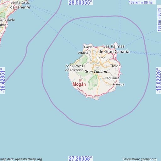
Mogán GPS coordinates[2]
27° 53' 1.86" North, 15° 43' 31.368" West
| Map corner | latitude | longitude |
|---|---|---|
| Upper-left | 28.50355°, | -16.42851° |
| Center: | 27.88385°, | -15.72538° |
| Lower-right: | 27.26058°, | -15.02226° |
| Map W x H: | 138.2×138.2 km | = 85.9×85.9mi |
| max Lat: | 43.74134° ⇑99.9% North |
| Mogán: | 27.88385° |
| min Lat: | ⇓0.1% South 27.64134° |
| min Long | Mogán | max Long |
| -18.00367° | -15.72538° | 4.2899° |
| W 0.9%⇐ | ⇒99.1% E |
Elevation
Elevation of Mogán is 238 m = 781 ft, and this is 360 m = 1181 ft below average elevation for this country.
| Max E: |
1682 m = 5518 ft | 79% |
| Avg. | 598 m = 1962 ft | |
| Mogán | 238 m = 781 ft | |
Min E: |
0 m = 0 ft | 21% |
See also: Spain elevation on elevation.city.
Geographical zone
Mogán is located in North temperate zone (between Tropic of Cancer and the Arctic Circle). Distance of this Northern Tropic circle is 494.5 km =307.3 mi to South.| Distance of | km | miles | from Mogán |
|---|---|---|---|
| North Pole | 6906.7 | 4291.6 | to North |
| Arctic Circle | 4300.8 | 2672.4 | to North |
| Tropic Cancer | 494.5 | 307.3 | to South |
| Equator | 3100.4 | 1926.5 | to South |


Nearby cities:
15 places around Mogán: (largest is in red/bold)
• Agaete
24.2 km =15 mi,  5°
5°
• Agüimes
27.6 km =17.1 mi,  85°
85°
• Artenara
17 km =10.6 mi,  26°
26°
• Maspalomas
19.4 km =12.1 mi,  135°
135°
• Playa del Ingles
20.2 km =12.6 mi,  134°
134°
• Puerto Rico
10.6 km =6.6 mi,  172°
172°
• San Bartolomé de Tirajana
15.6 km =9.7 mi,  73°
73°
• San Nicolás
12.9 km =8 mi,  334°
334°
• Santa Brígida
27.3 km =17 mi,  52°
52°
• Santa Lucía
18.4 km =11.4 mi,  80°
80°
• Tejeda
16.4 km =10.2 mi,  41°
41°
• Teror
26.2 km =16.3 mi, 41°
• Valleseco
23 km =14.3 mi, 39°
• Valsequillo de Gran Canaria
25.1 km =15.6 mi,  63°
63°
• Vega de San Mateo
23.4 km =14.5 mi, 53°
Sources, notices
• [Note1] Compared only with cities in Spain existing in our database
• [Src1] Map data: © OpenStreetMap contributors (CC-BY-SA)
• [Src2] Other city data from geonames.org with taken over terms of usage.
• [Src3] Geographical zone / Annual Mean Temperature by Robert A. Rohde @ Wikipedia
