San Miguel de Salinas geodata
San Miguel de Salinas (Valencia) is a seat of a third-order administrative division; located in Spain in Europe/Madrid (GMT+2) time zone. With population of 6,281 people, there are 1101 cities with bigger population in this country. Compared to other cities in Spain, 88.7% of cities are located further ↑North; 79% of cities are located further ←West and 89.2% of cities have higher elevation than San Miguel de Salinas. Note1
Administrative division(s):
- Level 1: Valencia
- Level 2: Provincia de Alicante
- Level 3: San Miguel de Salinas
Current local time in San Miguel de Salinas:
09:14 PM, ThursdayDifference from your time zone: hours


San Miguel de Salinas GPS coordinates[2]
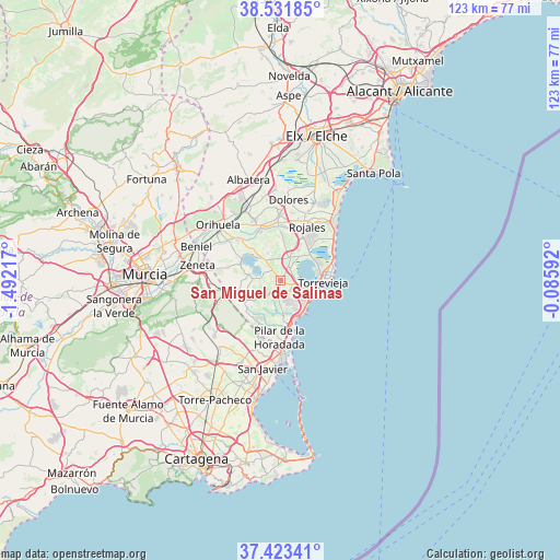
37° 58' 46.992" North, 0° 47' 20.544" West
| Map corner | latitude | longitude |
|---|---|---|
| Upper-left | 38.53185°, | -1.49217° |
| Center: | 37.97972°, | -0.78904° |
| Lower-right: | 37.42341°, | -0.08592° |
| Map W x H: | 123.2×123.2 km | = 76.6×76.6mi |
| max Lat: | 43.74134° ⇑88.7% North |
| San Miguel de Salinas: | 37.97972° |
| min Lat: | ⇓11.3% South 27.64134° |
| min Long | San Miguel de S | max Long |
| -18.00367° | -0.78904° | 4.2899° |
| W 79%⇐ | ⇒21% E |
Elevation
Elevation of San Miguel de Salinas is 78 m = 256 ft, and this is 520 m = 1706 ft below average elevation for this country.
| Max E: |
1682 m = 5518 ft | 89.2% |
| Avg. | 598 m = 1962 ft | |
| San Miguel de Salinas | 78 m = 256 ft | |
Min E: |
0 m = 0 ft | 10.8% |
See also: Spain elevation on elevation.city.
Geographical zone
San Miguel de Salinas is located in North temperate zone (between Tropic of Cancer and the Arctic Circle). Distance of this Northern Tropic circle is 1617 km =1004.8 mi to South.| Distance of | km | miles | from San Miguel de Salinas |
|---|---|---|---|
| North Pole | 5784.1 | 3594.1 | to North |
| Arctic Circle | 3178.2 | 1974.8 | to North |
| Tropic Cancer | 1617 | 1004.8 | to South |
| Equator | 4222.9 | 2624 | to South |


Nearby cities:
15 places around San Miguel de Salinas: (largest is in red/bold)
• Algorfa
11.9 km =7.4 mi,  356°
356°
• Almoradí
14.4 km =8.9 mi, 358°
• Benejúzar
11.7 km =7.3 mi,  337°
337°
• Benijofar
11.8 km =7.3 mi,  22°
22°
• Bigastro
13.3 km =8.3 mi,  313°
313°
• Daya Nueva
15 km =9.3 mi,  9°
9°
• Daya Vieja
14.6 km =9.1 mi, 17°
• Formentera de Segura
12.3 km =7.6 mi, 17°
• Jacarilla
11.5 km =7.1 mi,  322°
322°
• Los Montesinos
6.6 km =4.1 mi,  35°
35°
• Pilar de la Horadada
12.7 km =7.9 mi,  181°
181°
• Rafal
14.8 km =9.2 mi, 339°
• Rojales
13.3 km =8.3 mi, 24°
• Torre de la Horadada
12.5 km =7.8 mi,  167°
167°
• Torrevieja
9.4 km =5.8 mi,  90°
90°
Sources, notices
• [Note1] Compared only with cities in Spain existing in our database
• [Src1] Map data: © OpenStreetMap contributors (CC-BY-SA)
• [Src2] Other city data from geonames.org with taken over terms of usage.
• [Src3] Geographical zone / Annual Mean Temperature by Robert A. Rohde @ Wikipedia
