Benijofar geodata
Benijofar (Valencia) is a seat of a third-order administrative division; located in Spain in Europe/Madrid (GMT+2) time zone. With population of 3,467 people, there are 1593 cities with bigger population in this country. Compared to other cities in Spain, 88% of cities are located further ↑North; 79.6% of cities are located further ←West and 92.3% of cities have higher elevation than Benijofar. Note1


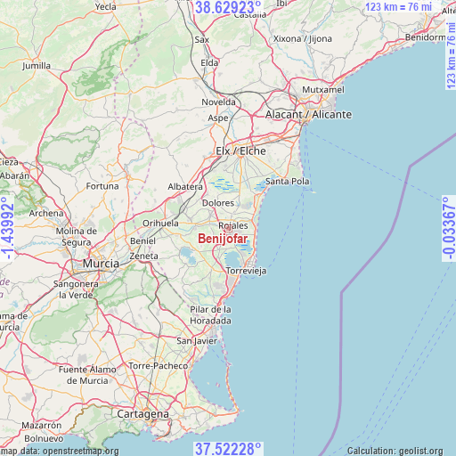
Benijofar GPS coordinates[2]
38° 4' 40.26" North, 0° 44' 12.48" West
| Map corner | latitude | longitude |
|---|---|---|
| Upper-left | 38.62923°, | -1.43992° |
| Center: | 38.07785°, | -0.7368° |
| Lower-right: | 37.52228°, | -0.03367° |
| Map W x H: | 123.1×123.1 km | = 76.5×76.5mi |
| max Lat: | 43.74134° ⇑88% North |
| Benijofar: | 38.07785° |
| min Lat: | ⇓12% South 27.64134° |
| min Long | Benijofar | max Long |
| -18.00367° | -0.7368° | 4.2899° |
| W 79.6%⇐ | ⇒20.4% E |
Elevation
Elevation of Benijofar is 43 m = 141 ft, and this is 555 m = 1821 ft below average elevation for this country.
| Max E: |
1682 m = 5518 ft | 92.3% |
| Avg. | 598 m = 1962 ft | |
| Benijofar | 43 m = 141 ft | |
Min E: |
0 m = 0 ft | 7.7% |
See also: Spain elevation on elevation.city.
Geographical zone
Benijofar is located in North temperate zone (between Tropic of Cancer and the Arctic Circle). Distance of this Northern Tropic circle is 1627.9 km =1011.5 mi to South.| Distance of | km | miles | from Benijofar |
|---|---|---|---|
| North Pole | 5773.2 | 3587.3 | to North |
| Arctic Circle | 3167.3 | 1968.1 | to North |
| Tropic Cancer | 1627.9 | 1011.5 | to South |
| Equator | 4233.9 | 2630.8 | to South |


Nearby cities:
15 places around Benijofar: (largest is in red/bold)
• Algorfa
5.3 km =3.3 mi,  280°
280°
• Almoradí
5.9 km =3.7 mi,  305°
305°
• Benejúzar
9 km =5.6 mi,  269°
269°
• Catral
10.8 km =6.7 mi,  328°
328°
• Daya Nueva
4.4 km =2.7 mi, 332°
• Daya Vieja
3 km =1.9 mi,  357°
357°
• Dolores
7.5 km =4.7 mi,  336°
336°
• Formentera de Segura
1.1 km =0.7 mi, 314°
• Guardamar del Segura
7.2 km =4.5 mi,  78°
78°
• Jacarilla
11.6 km =7.2 mi,  261°
261°
• Los Montesinos
5.6 km =3.5 mi,  187°
187°
• Rafal
10.3 km =6.4 mi,  286°
286°
• Rojales
1.5 km =0.9 mi,  41°
41°
• San Miguel de Salinas
11.8 km =7.3 mi,  202°
202°
• Torrevieja
12 km =7.5 mi,  156°
156°
Sources, notices
• [Note1] Compared only with cities in Spain existing in our database
• [Src1] Map data: © OpenStreetMap contributors (CC-BY-SA)
• [Src2] Other city data from geonames.org with taken over terms of usage.
• [Src3] Geographical zone / Annual Mean Temperature by Robert A. Rohde @ Wikipedia
