Almoradí geodata
Almoradí (Valencia) is a populated place; located in Spain in Europe/Madrid (GMT+2) time zone. With population of 19,147 people, there are 493 cities with bigger population in this country. Compared to other cities in Spain, 87.7% of cities are located further ↑North; 78.9% of cities are located further ←West and 96.6% of cities have higher elevation than Almoradí. Note1


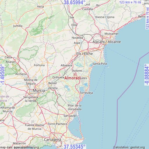
Almoradí GPS coordinates[2]
38° 6' 31.644" North, 0° 47' 31.092" West
| Map corner | latitude | longitude |
|---|---|---|
| Upper-left | 38.65994°, | -1.49509° |
| Center: | 38.10879°, | -0.79197° |
| Lower-right: | 37.55345°, | -0.08884° |
| Map W x H: | 123×123 km | = 76.4×76.4mi |
| max Lat: | 43.74134° ⇑87.7% North |
| Almoradí: | 38.10879° |
| min Lat: | ⇓12.3% South 27.64134° |
| min Long | Almoradí | max Long |
| -18.00367° | -0.79197° | 4.2899° |
| W 78.9%⇐ | ⇒21.1% E |
Elevation
Elevation of Almoradí is 17 m = 56 ft, and this is 581 m = 1906 ft below average elevation for this country.
| Max E: |
1682 m = 5518 ft | 96.6% |
| Avg. | 598 m = 1962 ft | |
| Almoradí | 17 m = 56 ft | |
Min E: |
0 m = 0 ft | 3.4% |
See also: Spain elevation on elevation.city.
Geographical zone
Almoradí is located in North temperate zone (between Tropic of Cancer and the Arctic Circle). Distance of this Northern Tropic circle is 1631.4 km =1013.7 mi to South.| Distance of | km | miles | from Almoradí |
|---|---|---|---|
| North Pole | 5769.8 | 3585.2 | to North |
| Arctic Circle | 3163.9 | 1966 | to North |
| Tropic Cancer | 1631.4 | 1013.7 | to South |
| Equator | 4237.3 | 2632.9 | to South |


Nearby cities:
15 places around Almoradí: (largest is in red/bold)
• Algorfa
2.5 km =1.6 mi,  188°
188°
• Benejúzar
5.4 km =3.4 mi,  229°
229°
• Benijofar
5.9 km =3.7 mi,  125°
125°
• Callosa de Segura
7.8 km =4.8 mi,  283°
283°
• Catral
5.8 km =3.6 mi,  351°
351°
• Cox
9.1 km =5.7 mi,  293°
293°
• Daya Nueva
2.8 km =1.7 mi,  80°
80°
• Daya Vieja
4.7 km =2.9 mi,  95°
95°
• Dolores
3.9 km =2.4 mi,  27°
27°
• Formentera de Segura
4.8 km =3 mi,  123°
123°
• Jacarilla
8.4 km =5.2 mi, 232°
• Los Montesinos
9.9 km =6.2 mi,  155°
155°
• Rafal
5 km =3.1 mi,  264°
264°
• Rojales
6.3 km =3.9 mi,  111°
111°
• San Isidro
8.2 km =5.1 mi,  329°
329°
Sources, notices
• [Note1] Compared only with cities in Spain existing in our database
• [Src1] Map data: © OpenStreetMap contributors (CC-BY-SA)
• [Src2] Other city data from geonames.org with taken over terms of usage.
• [Src3] Geographical zone / Annual Mean Temperature by Robert A. Rohde @ Wikipedia
