Benejúzar geodata
Benejúzar (Valencia) is a seat of a third-order administrative division; located in Spain in Europe/Madrid (GMT+2) time zone. With population of 5,295 people, there are 1248 cities with bigger population in this country. Compared to other cities in Spain, 88% of cities are located further ↑North; 78.4% of cities are located further ←West and 94.4% of cities have higher elevation than Benejúzar. Note1


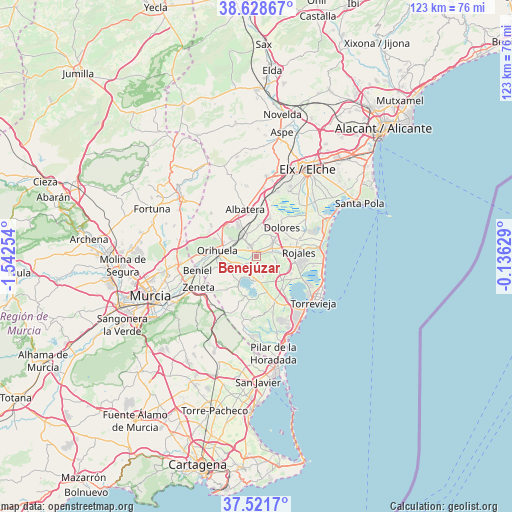
Benejúzar GPS coordinates[2]
38° 4' 38.208" North, 0° 50' 21.912" West
| Map corner | latitude | longitude |
|---|---|---|
| Upper-left | 38.62867°, | -1.54254° |
| Center: | 38.07728°, | -0.83942° |
| Lower-right: | 37.5217°, | -0.13629° |
| Map W x H: | 123.1×123.1 km | = 76.5×76.5mi |
| max Lat: | 43.74134° ⇑88% North |
| Benejúzar: | 38.07728° |
| min Lat: | ⇓12% South 27.64134° |
| min Long | Benejúzar | max Long |
| -18.00367° | -0.83942° | 4.2899° |
| W 78.4%⇐ | ⇒21.6% E |
Elevation
Elevation of Benejúzar is 28 m = 92 ft, and this is 570 m = 1870 ft below average elevation for this country.
| Max E: |
1682 m = 5518 ft | 94.4% |
| Avg. | 598 m = 1962 ft | |
| Benejúzar | 28 m = 92 ft | |
Min E: |
0 m = 0 ft | 5.6% |
See also: Spain elevation on elevation.city.
Geographical zone
Benejúzar is located in North temperate zone (between Tropic of Cancer and the Arctic Circle). Distance of this Northern Tropic circle is 1627.9 km =1011.5 mi to South.| Distance of | km | miles | from Benejúzar |
|---|---|---|---|
| North Pole | 5773.3 | 3587.4 | to North |
| Arctic Circle | 3167.4 | 1968.1 | to North |
| Tropic Cancer | 1627.9 | 1011.5 | to South |
| Equator | 4233.8 | 2630.8 | to South |


Nearby cities:
15 places around Benejúzar: (largest is in red/bold)
• Algorfa
3.9 km =2.4 mi,  74°
74°
• Almoradí
5.4 km =3.4 mi,  49°
49°
• Benijofar
9 km =5.6 mi,  89°
89°
• Bigastro
5.4 km =3.4 mi,  252°
252°
• Callosa de Segura
6.3 km =3.9 mi,  327°
327°
• Cox
8.3 km =5.2 mi, 329°
• Daya Nueva
8 km =5 mi,  60°
60°
• Daya Vieja
9.4 km =5.8 mi, 70°
• Dolores
9.2 km =5.7 mi,  40°
40°
• Formentera de Segura
8.2 km =5.1 mi,  83°
83°
• Granja de Rocamora
9.4 km =5.8 mi, 331°
• Jacarilla
3 km =1.9 mi,  236°
236°
• Orihuela
9.2 km =5.7 mi,  275°
275°
• Rafal
3.2 km =2 mi,  344°
344°
• Redován
7.5 km =4.7 mi,  305°
305°
Sources, notices
• [Note1] Compared only with cities in Spain existing in our database
• [Src1] Map data: © OpenStreetMap contributors (CC-BY-SA)
• [Src2] Other city data from geonames.org with taken over terms of usage.
• [Src3] Geographical zone / Annual Mean Temperature by Robert A. Rohde @ Wikipedia
