Jacarilla geodata
Jacarilla (Valencia) is a seat of a third-order administrative division; located in Spain in Europe/Madrid (GMT+2) time zone. With population of 1,723 people, there are 2322 cities with bigger population in this country. Compared to other cities in Spain, 88.1% of cities are located further ↑North; 78.2% of cities are located further ←West and 94.9% of cities have higher elevation than Jacarilla. Note1


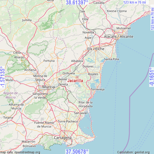
Jacarilla GPS coordinates[2]
38° 3' 44.892" North, 0° 52' 5.592" West
| Map corner | latitude | longitude |
|---|---|---|
| Upper-left | 38.61397°, | -1.57135° |
| Center: | 38.06247°, | -0.86822° |
| Lower-right: | 37.50678°, | -0.1651° |
| Map W x H: | 123.1×123.1 km | = 76.5×76.5mi |
| max Lat: | 43.74134° ⇑88.1% North |
| Jacarilla: | 38.06247° |
| min Lat: | ⇓11.9% South 27.64134° |
| min Long | Jacarilla | max Long |
| -18.00367° | -0.86822° | 4.2899° |
| W 78.2%⇐ | ⇒21.8% E |
Elevation
Elevation of Jacarilla is 25 m = 82 ft, and this is 573 m = 1880 ft below average elevation for this country.
| Max E: |
1682 m = 5518 ft | 94.9% |
| Avg. | 598 m = 1962 ft | |
| Jacarilla | 25 m = 82 ft | |
Min E: |
0 m = 0 ft | 5.1% |
See also: Spain elevation on elevation.city.
Geographical zone
Jacarilla is located in North temperate zone (between Tropic of Cancer and the Arctic Circle). Distance of this Northern Tropic circle is 1626.2 km =1010.5 mi to South.| Distance of | km | miles | from Jacarilla |
|---|---|---|---|
| North Pole | 5774.9 | 3588.4 | to North |
| Arctic Circle | 3169 | 1969.1 | to North |
| Tropic Cancer | 1626.2 | 1010.5 | to South |
| Equator | 4232.1 | 2629.7 | to South |


Nearby cities:
15 places around Jacarilla: (largest is in red/bold)
• Algorfa
6.8 km =4.2 mi,  67°
67°
• Almoradí
8.4 km =5.2 mi,  52°
52°
• Benejúzar
3 km =1.9 mi,  56°
56°
• Benijofar
11.6 km =7.2 mi,  81°
81°
• Bigastro
2.6 km =1.6 mi,  269°
269°
• Callosa de Segura
7 km =4.3 mi,  352°
352°
• Cox
9 km =5.6 mi, 349°
• Daya Nueva
11 km =6.8 mi, 59°
• Formentera de Segura
11 km =6.8 mi, 76°
• Granja de Rocamora
10.1 km =6.3 mi, 348°
• Los Montesinos
11.4 km =7.1 mi,  109°
109°
• Orihuela
7.1 km =4.4 mi,  290°
290°
• Rafal
5 km =3.1 mi,  19°
19°
• Redován
7 km =4.3 mi,  328°
328°
• San Miguel de Salinas
11.5 km =7.1 mi,  142°
142°
Sources, notices
• [Note1] Compared only with cities in Spain existing in our database
• [Src1] Map data: © OpenStreetMap contributors (CC-BY-SA)
• [Src2] Other city data from geonames.org with taken over terms of usage.
• [Src3] Geographical zone / Annual Mean Temperature by Robert A. Rohde @ Wikipedia
