Daya Vieja geodata
Daya Vieja (Valencia) is a seat of a third-order administrative division; located in Spain in Europe/Madrid (GMT+2) time zone. With population of 295 people, there are 4524 cities with bigger population in this country. Compared to other cities in Spain, 87.8% of cities are located further ↑North; 79.5% of cities are located further ←West and 99.2% of cities have higher elevation than Daya Vieja. Note1


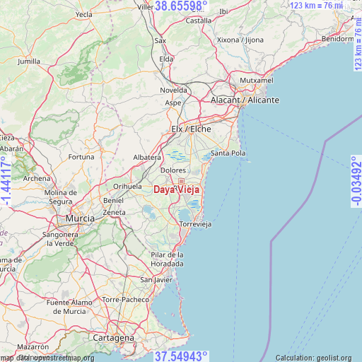
Daya Vieja GPS coordinates[2]
38° 6' 17.28" North, 0° 44' 16.944" West
| Map corner | latitude | longitude |
|---|---|---|
| Upper-left | 38.65598°, | -1.44117° |
| Center: | 38.1048°, | -0.73804° |
| Lower-right: | 37.54943°, | -0.03492° |
| Map W x H: | 123×123 km | = 76.4×76.4mi |
| max Lat: | 43.74134° ⇑87.8% North |
| Daya Vieja: | 38.1048° |
| min Lat: | ⇓12.2% South 27.64134° |
| min Long | Daya Vieja | max Long |
| -18.00367° | -0.73804° | 4.2899° |
| W 79.5%⇐ | ⇒20.5% E |
Elevation
Elevation of Daya Vieja is 7 m = 23 ft, and this is 591 m = 1939 ft below average elevation for this country.
| Max E: |
1682 m = 5518 ft | 99.2% |
| Avg. | 598 m = 1962 ft | |
| Daya Vieja | 7 m = 23 ft | |
Min E: |
0 m = 0 ft | 0.8% |
See also: Spain elevation on elevation.city.
Geographical zone
Daya Vieja is located in North temperate zone (between Tropic of Cancer and the Arctic Circle). Distance of this Northern Tropic circle is 1630.9 km =1013.4 mi to South.| Distance of | km | miles | from Daya Vieja |
|---|---|---|---|
| North Pole | 5770.2 | 3585.4 | to North |
| Arctic Circle | 3164.3 | 1966.2 | to North |
| Tropic Cancer | 1630.9 | 1013.4 | to South |
| Equator | 4236.9 | 2632.7 | to South |


Nearby cities:
15 places around Daya Vieja: (largest is in red/bold)
• Algorfa
5.5 km =3.4 mi,  248°
248°
• Almoradí
4.7 km =2.9 mi,  275°
275°
• Benejúzar
9.4 km =5.8 mi, 250°
• Benijofar
3 km =1.9 mi,  177°
177°
• Callosa de Segura
12.5 km =7.8 mi, 280°
• Catral
8.4 km =5.2 mi,  317°
317°
• Daya Nueva
2.2 km =1.4 mi,  295°
295°
• Dolores
4.9 km =3 mi, 323°
• Formentera de Segura
2.3 km =1.4 mi,  197°
197°
• Guardamar del Segura
7.4 km =4.6 mi,  102°
102°
• Jacarilla
12.3 km =7.6 mi, 247°
• Los Montesinos
8.5 km =5.3 mi, 184°
• Rafal
9.7 km =6 mi,  269°
269°
• Rojales
2.2 km =1.4 mi,  149°
149°
• San Isidro
11.6 km =7.2 mi,  310°
310°
Sources, notices
• [Note1] Compared only with cities in Spain existing in our database
• [Src1] Map data: © OpenStreetMap contributors (CC-BY-SA)
• [Src2] Other city data from geonames.org with taken over terms of usage.
• [Src3] Geographical zone / Annual Mean Temperature by Robert A. Rohde @ Wikipedia
