Matalascañas geodata
Matalascañas (Andalusia) is a populated place; located in Spain in Europe/Madrid (GMT+2) time zone. With population of 785 people, there are 3243 cities with bigger population in this country. Compared to other cities in Spain, 95.2% of cities are located further ↑North; 91.6% of cities are located further →East and 96.6% of cities have higher elevation than Matalascañas. Note1


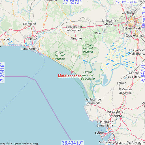
Matalascañas GPS coordinates[2]
36° 59' 52.152" North, 6° 33' 3.708" West
| Map corner | latitude | longitude |
|---|---|---|
| Upper-left | 37.5573°, | -7.25416° |
| Center: | 36.99782°, | -6.55103° |
| Lower-right: | 36.43419°, | -5.84791° |
| Map W x H: | 124.9×124.9 km | = 77.6×77.6mi |
| max Lat: | 43.74134° ⇑95.2% North |
| Matalascañas: | 36.99782° |
| min Lat: | ⇓4.8% South 27.64134° |
| min Long | Matalascañas | max Long |
| -18.00367° | -6.55103° | 4.2899° |
| W 8.4%⇐ | ⇒91.6% E |
Elevation
Elevation of Matalascañas is 17 m = 56 ft, and this is 581 m = 1906 ft below average elevation for this country.
| Max E: |
1682 m = 5518 ft | 96.6% |
| Avg. | 598 m = 1962 ft | |
| Matalascañas | 17 m = 56 ft | |
Min E: |
0 m = 0 ft | 3.4% |
See also: Spain elevation on elevation.city.
Geographical zone
Matalascañas is located in North temperate zone (between Tropic of Cancer and the Arctic Circle). Distance of this Northern Tropic circle is 1507.9 km =937 mi to South.| Distance of | km | miles | from Matalascañas |
|---|---|---|---|
| North Pole | 5893.3 | 3661.9 | to North |
| Arctic Circle | 3287.4 | 2042.7 | to North |
| Tropic Cancer | 1507.9 | 937 | to South |
| Equator | 4113.8 | 2556.2 | to South |


Nearby cities:
15 places around Matalascañas: (largest is in red/bold)
• Almonte
29.8 km =18.5 mi,  5°
5°
• Bollullos par del Condado
38.2 km =23.7 mi,  1°
1°
• Bonares
38.1 km =23.7 mi,  342°
342°
• Chipiona
30.8 km =19.1 mi,  160°
160°
• Hinojos
36.1 km =22.4 mi,  25°
25°
• Lucena del Puerto
37.5 km =23.3 mi, 335°
• Mazagón
29 km =18 mi,  302°
302°
• Moguer
40 km =24.9 mi,  320°
320°
• Niebla
42.1 km =26.2 mi, 344°
• Palos de la Frontera
40.3 km =25 mi,  310°
310°
• Pilas
40.6 km =25.2 mi, 33°
• Punta Umbría
42.1 km =26.2 mi, 299°
• Sanlúcar de Barrameda
30.2 km =18.8 mi,  144°
144°
• Trebujena
36.2 km =22.5 mi,  112°
112°
• Villamanrique de la Condesa
35 km =21.7 mi,  38°
38°
Sources, notices
• [Note1] Compared only with cities in Spain existing in our database
• [Src1] Map data: © OpenStreetMap contributors (CC-BY-SA)
• [Src2] Other city data from geonames.org with taken over terms of usage.
• [Src3] Geographical zone / Annual Mean Temperature by Robert A. Rohde @ Wikipedia
