Lebrija geodata
Lebrija (Andalusia) is a seat of a third-order administrative division; located in Spain in Europe/Madrid (GMT+2) time zone. With population of 26,434 people, there are 354 cities with bigger population in this country. Compared to other cities in Spain, 96% of cities are located further ↑North; 87.1% of cities are located further →East and 92.5% of cities have higher elevation than Lebrija. Note1


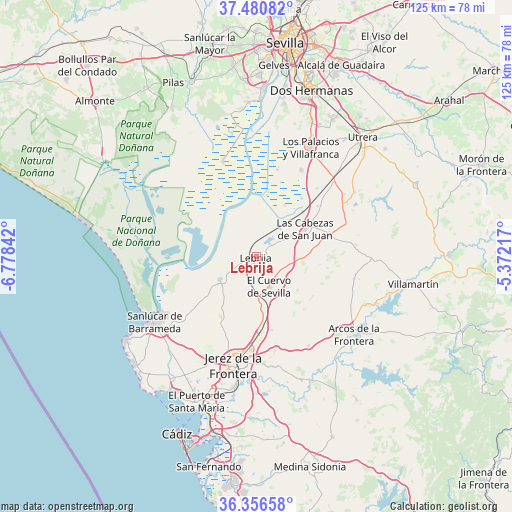
Lebrija GPS coordinates[2]
36° 55' 14.772" North, 6° 4' 31.044" West
| Map corner | latitude | longitude |
|---|---|---|
| Upper-left | 37.48082°, | -6.77842° |
| Center: | 36.92077°, | -6.07529° |
| Lower-right: | 36.35658°, | -5.37217° |
| Map W x H: | 125×125 km | = 77.7×77.7mi |
| max Lat: | 43.74134° ⇑96% North |
| Lebrija: | 36.92077° |
| min Lat: | ⇓4% South 27.64134° |
| min Long | Lebrija | max Long |
| -18.00367° | -6.07529° | 4.2899° |
| W 12.9%⇐ | ⇒87.1% E |
Elevation
Elevation of Lebrija is 41 m = 135 ft, and this is 557 m = 1827 ft below average elevation for this country.
| Max E: |
1682 m = 5518 ft | 92.5% |
| Avg. | 598 m = 1962 ft | |
| Lebrija | 41 m = 135 ft | |
Min E: |
0 m = 0 ft | 7.5% |
See also: Spain elevation on elevation.city.
Geographical zone
Lebrija is located in North temperate zone (between Tropic of Cancer and the Arctic Circle). Distance of this Northern Tropic circle is 1499.3 km =931.6 mi to South.| Distance of | km | miles | from Lebrija |
|---|---|---|---|
| North Pole | 5901.9 | 3667.3 | to North |
| Arctic Circle | 3296 | 2048 | to North |
| Tropic Cancer | 1499.3 | 931.6 | to South |
| Equator | 4105.2 | 2550.9 | to South |


Nearby cities:
15 places around Lebrija: (largest is in red/bold)
• Arcos de la Frontera
30.2 km =18.8 mi,  128°
128°
• Bornos
31.6 km =19.6 mi,  111°
111°
• Chipiona
38.2 km =23.7 mi,  237°
237°
• Coria del Río
40.8 km =25.4 mi,  2°
2°
• El Cuervo
8.2 km =5.1 mi,  156°
156°
• El Puerto de Santa María
39 km =24.2 mi,  201°
201°
• Espera
24.5 km =15.2 mi,  102°
102°
• Jerez de la Frontera
26.6 km =16.5 mi,  191°
191°
• La Puebla del Río
38.6 km =24 mi, 1°
• Las Cabezas de San Juan
14 km =8.7 mi,  59°
59°
• Los Palacios y Villafranca
30 km =18.6 mi,  26°
26°
• Sanlúcar de Barrameda
29.3 km =18.2 mi, 237°
• Trebujena
10.5 km =6.5 mi, 238°
• Utrera
39.3 km =24.4 mi,  41°
41°
• Villamartín
38.9 km =24.2 mi, 100°
Sources, notices
• [Note1] Compared only with cities in Spain existing in our database
• [Src1] Map data: © OpenStreetMap contributors (CC-BY-SA)
• [Src2] Other city data from geonames.org with taken over terms of usage.
• [Src3] Geographical zone / Annual Mean Temperature by Robert A. Rohde @ Wikipedia
