Rosalejo geodata
Rosalejo (Extremadura) is a populated place; located in Spain in Europe/Madrid (GMT+2) time zone. With population of 1,376 people, there are 2569 cities with bigger population in this country. Compared to other cities in Spain, 77.5% of cities are located further ↑North; 71.2% of cities are located further →East and 62.3% of cities have higher elevation than Rosalejo. Note1


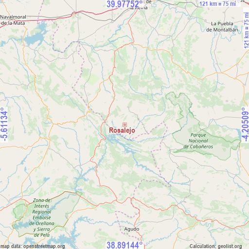
Rosalejo GPS coordinates[2]
39° 26' 11.76" North, 4° 54' 29.556" West
| Map corner | latitude | longitude |
|---|---|---|
| Upper-left | 39.97752°, | -5.61134° |
| Center: | 39.4366°, | -4.90821° |
| Lower-right: | 38.89144°, | -4.20509° |
| Map W x H: | 120.8×120.8 km | = 75.1×75.1mi |
| max Lat: | 43.74134° ⇑77.5% North |
| Rosalejo: | 39.4366° |
| min Lat: | ⇓22.5% South 27.64134° |
| min Long | Rosalejo | max Long |
| -18.00367° | -4.90821° | 4.2899° |
| W 28.8%⇐ | ⇒71.2% E |
Elevation
Elevation of Rosalejo is 495 m = 1624 ft, and this is 103 m = 338 ft below average elevation for this country.
| Max E: |
1682 m = 5518 ft | 62.3% |
| Avg. | 598 m = 1962 ft | |
| Rosalejo | 495 m = 1624 ft | |
Min E: |
0 m = 0 ft | 37.7% |
See also: Spain elevation on elevation.city.
Geographical zone
Rosalejo is located in North temperate zone (between Tropic of Cancer and the Arctic Circle). Distance of this Northern Tropic circle is 1779 km =1105.4 mi to South.| Distance of | km | miles | from Rosalejo |
|---|---|---|---|
| North Pole | 5622.1 | 3493.4 | to North |
| Arctic Circle | 3016.2 | 1874.2 | to North |
| Tropic Cancer | 1779 | 1105.4 | to South |
| Equator | 4384.9 | 2724.6 | to South |


Nearby cities:
15 places around Rosalejo: (largest is in red/bold)
• Aldeanueva de San Bartolomé
28.3 km =17.6 mi,  321°
321°
• Alía
26.6 km =16.5 mi,  272°
272°
• Anchuras
8 km =5 mi,  52°
52°
• Castilblanco
23.1 km =14.4 mi,  222°
222°
• Espinoso del Rey
26.4 km =16.4 mi,  23°
23°
• Helechosa
13.9 km =8.6 mi,  180°
180°
• Herrera del Duque
32.2 km =20 mi,  202°
202°
• La Nava de Ricomalillo
24.7 km =15.3 mi,  343°
343°
• Mohedas de la Jara
27.4 km =17 mi,  312°
312°
• Navas de Estena
33.8 km =21 mi,  78°
78°
• Puerto de San Vicente
20.1 km =12.5 mi,  298°
298°
• Sevilleja de la Jara
16.1 km =10 mi, 342°
• Torrecilla de la Jara
32 km =19.9 mi, 21°
• Valdecaballeros
32.4 km =20.1 mi,  228°
228°
• Villarta de los Montes
26.7 km =16.6 mi,  158°
158°
Sources, notices
• [Note1] Compared only with cities in Spain existing in our database
• [Src1] Map data: © OpenStreetMap contributors (CC-BY-SA)
• [Src2] Other city data from geonames.org with taken over terms of usage.
• [Src3] Geographical zone / Annual Mean Temperature by Robert A. Rohde @ Wikipedia
